Platforms: iPhone, iPad, iPod Touch, Apple iPhone OS
Categories: Travel & Navigation
Upload date: 29 Sep 11
Developer: National Geographic Society
License: Commercial
Price: 4.99 $
Downloads: 26
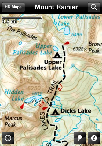
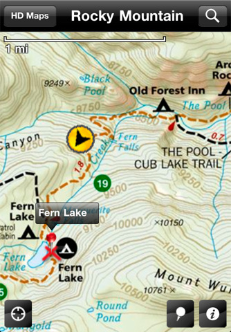
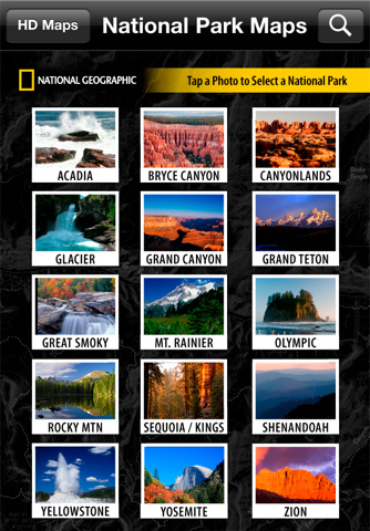
National Park Maps HD - Explore 15 of the top US National Parks with the best collection of trail maps available. National Geographic - THE place for maps - has opened up their best-selling, detailed Trails Illustrated National Parks Maps for download to your favorite Apple device. Plan your trip by browsing the maps and marking places you'd like to see. When visiting, use your iPhone or iPad to help you find your way around the park. A great gift application for your favorite outdoor adventurer, family trip planner or armchair explorer! MAPS FOR 15 GREAT NATIONAL PARKS:
· Acadia - Bryce Canyon - Canyonlands - Glacier/Waterton - Grand Canyon - Grand Teton - Great Smoky Mountains - Mount Rainier - Olympic - Rocky Mountain - Sequoia/Kings Canyon - Shenandoah - Yellowstone - Yosemite - Zion
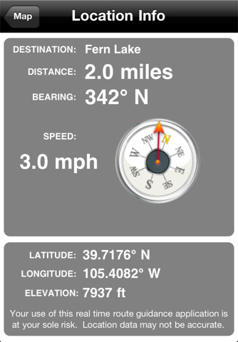
MAPS THAT KNOW WHERE YOU ARE:
· See your current position on the map
· Know how far it is to your destination
· Mark your campsite or car for an easy return
MAPS THAT KNOW WHAT'S AROUND YOU:
· Search for places by name or browse by category to see what's nearby
· Find campgrounds, picnic areas, visitor centers and other facilities
· Find trails, waterfalls, lakes, summits and other points of interest
MAPS THAT GET YOU WHERE YOU WANT TO GO:
· Includes National Park Service maps to get you around the park
· Plus more detailed Trails Illustrated maps to get you off the beaten path
· Download HD maps for even more zoom levels at no additional charge
· Bonus trip planning info - park phone numbers, campground lists, and more
· Offline access - maps work without any cell or WiFi connection
A GREAT VALUE:
· Contains a retail equivalent of over $300.00 of detailed Trails Illustrated Maps
What's New in This Release:
· Enhanced zoom functionality
Like it? Share with your friends!
If you got an error while installing Themes, Software or Games, please, read FAQ.
Supported operating systems:
Apple iOS 10.x (iPad), Apple iOS 10.x (iPhone), Apple iOS 11.x (iPad), Apple iOS 12.x (iPad), Apple iOS 12.x (iPhone), Apple iOS 4.0.x (iPhone), Apple iOS 4.0.x (iPod Touch), Apple iOS 4.2.x (iPad), Apple iOS 4.2.x (iPhone), Apple iOS 4.2.x (iPod Touch), Apple iOS 4.3.x (iPad), Apple iOS 4.3.x (iPhone), Apple iOS 4.3.x (iPod Touch), Apple iOS 5.0 (iPad), Apple iOS 5.0 (iPhone), Apple iOS 5.0 (iPod Touch), Apple iOS 6.0 (iPad), Apple iOS 6.0 (iPhone), Apple iOS 6.0 (iPod Touch), Apple iOS 7.0 (iPad), Apple iOS 7.0 (iPhone), Apple iOS 7.0 (iPod Touch), Apple iOS 8.x (iPad), Apple iOS 8.x (iPhone), Apple iOS 8.x (iPod Touch), Apple iOS 9.x (iPad), Apple iOS 9.x (iPhone), Apple iOS 9.x (iPod Touch), Apple iPhone OS 3.1.x, Apple iPhone OS 3.1.x (iPod Touch), Apple iPhone OS 3.2.x (iPad)
Berlin Walking Tours and Map Berlin Walking Tours and Map - No need to hop on a tour bus or join a group; now you can explore all the best attractions on your own, at your own pace, and at a cost that is only a fraction of what you would normally pay for a guided tour
Erie (PA, USA) Map Offline Erie (PA, USA) Map Offline - This will be perfect when you are traveling and you don't have internet connection. This Offline Maps is not a replacement of Google Maps. It is used when you don't have internet connection and want to use maps
Shreveport (LA, USA) Map Offline Shreveport (LA, USA) Map Offline - This will be perfect when you are traveling and you don't have internet connection. This Offline Maps is not a replacement of Google Maps. It is used when you don't have internet connection and want to use maps
Kuala Lumpur Map Offline Kuala Lumpur Map Offline - This will be perfect when you are traveling and you don't have internet connection. This Offline Maps is not a replacement of Google Maps. It is used when you don't have internet connection and want to use maps
Ottawa Walking Tours and Map Ottawa Walking Tours and Map - No need to hop on a tour bus or join a group; now you can explore all the best attractions on your own, at your own pace, and at a cost that is only a fraction of what you would normally pay for a guided tour
New York Subway 10 for iPad New York Subway 10 - The “New York Subway” application is a superb geographically based map and route planner for the New York public transport systems
Wind Cave National Park - GPS Map Navigator Wind Cave National Park - GPS Map Navigator - Continues in the tradition of offering depth of information and functionality across expected places all over the world, exploring the map you get maximum details obtaining detailed information of each object on the map
Other Software by developer «National Geographic Society»:
National Geographic World Atlas National Geographic World Atlas - Designed specifically for the iPad, National Geographic's new and improved World Atlas HD puts our best maps in the palm of your hand
50Greatest Photographs of National Geographic 50 Greatest Photographs of National Geographic - National Geographic Magazine has searched its vast archives to find its most memorable photographs. This application brings National Geographic's 50 Greatest Photographs to life with the rich features and functionality of iPad
National Geographic Birds: Field Guide to North America National Geographic Birds: Field Guide to North America - Based on the best-selling book, National Geographic Field Guide to the Birds of North America, National Geographic Handheld Birds is a breakthrough in birding. It was the first North American multimedia software program to empower birders of all levels with easy-to-use interactive referencing capabilities
Build It Green: Back to the Beach Build It Green: Back to the Beach - Paradise Island is in trouble and it’s up to you turn it around. Taking the role of Mayor, you have 6I levels and 12 districts to play through, turning the island back into an environmentally friendly haven
50 Greatest Photographs of National Geographic 50 Greatest Photographs of National Geographic - National Geographic Magazine has searched its vast archives to find its most memorable photographs. This application brings National Geographic's 50 Greatest Photographs to life with the rich features and functionality of iPad
GeoBee Challenge HD by National Geographic GeoBee Challenge HD by National Geographic - Now with beautiful maps from National Geographic, explore the world while testing your smarts.
This is a challenging game, so it's not for beginners...but do keep in mind that the National Geographic Bee is meant for kids in grades 4-8.
Three types of game play make sure you really know your stuff and never get bored
Great Migrations Use your wits and skill to keep your animals from being attacked by hungry predators and on the path toward safety!
7 Billion 7 Billion - National Geographic magazine presents 7 Billion: How your world will change - to coincide with the arrival of the 7 billionth human being to our world. This application explores the challenges of a growing human population in a world of limited resources with informative videos, interactive maps, in-depth articles, and stunning photography
National Geographic Magazine National Geographic Magazine - Subscriptions to National Geographic magazine are now available! Download National Geographic magazine on iPad and you can get a sample issue for free!
National Geographic magazine on iPad showcases each month’s issue with exclusive content and enhanced functionality
Building Titanic Building Titanic - In 1912, she was the largest, most complex moving object on the planet and it took a workforce of thousands more than two years to bring her to life.
Now, with the free Building Titanic application, travel back in time and witness Titanic's construction

")


 Map Offline")

 Map Offline")


