London Tube 10 is a superb geographically based map and route planner for the London Underground, Overground, Docklands Light Railway (DLR), Croydon Tramlink and London Airport Express services. The map and routing information is stored completely on the device and needs no internet connection, making it ideal for iPad users visiting the UK who want to avoid paying roaming charges.
MAP
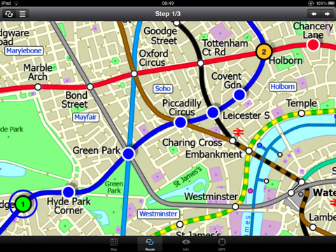
The map is hand drawn by Visual IT and provides a unique geographically based view of the city centre with many places of interest drawn directly on the background so you can easily get your bearings when traveling in and around the city. Tap on the map for location information, use the inbuilt search feature or choose from a list of locations. Places of interest, museums, hotels, parks, restaurant, shops, hospitals, streets, etc, are also included. The route planner will automatically suggest the nearest station to any place of interest you select.
MINUTE MAP
Another unique feature of is the “Minute Map” option which allows you to see the travel times from a start point to all other locations on the map. This can be very useful and is not available in any other product on the market.
INTERNET CONNECTION
The map and routing do not require an internet connection and you will not be charged data connection fees. This also means the application runs successfully underground.
ROUTING
Does not require an internet connection and will always be available to display a clear and detailed view of the city transport systems, plus list and animate the optimum route for your journey. Provides the fastest route calculations of any mobile routing application (virtually instantaneous) using actual published journey times with the ability to select the quickest route or the route with the least changes.
Comprehensive details of your planned route are provided, including changes, directions of travel, number of stops, predicted journey times, etc. Uniquely this application gives you “direction”, “towards” and “service frequency” information for each segment of the journey (not available on any other offline journey planner) for example “At Kings Cross change to the Hammersmith and City line (Eastbound) towards Barking for 3 stops. Service runs every 7 minutes” which is essential when finding the correct platform and connection. Also given are alternatives for each segment of the journey.
TRAIN + STATION EXITS
Contains simple information on every Tube station indicating what carriage to use for the most efficient exit or transfer. Just tap on a Tube station and scroll down to see the exit information for each platform.
LIVE INFO
When an internet connection is available, optional "Live Information" on the current state of the transport services can be viewed (and automatically saved for future reference) allowing you to plan your journeys in advance and avoid any potential delays. Unique to this application is the ability to turn off services that are out of action and automatically calculate an alternative route.
What's New in This Release:
· Completely new map and routing.
· Deep integration with inbuilt online mapping.
· Lots of new features.
· Bug fixes.
What's New in 1.6:
· Updated map and routing.
· London 2012 Olympic venues added.
What's New in 1.5:
· New, larger and more detailed map.
· Ability to measure distances and draw markups on the map.
· Lots of minor improvements.
What's New in 1.4:
· Updated map and routes.
· Faster map loading.
· New route description text and layout.
· New "Take me home" option.
· New "Recent routes" option.
· Improved Live Info, now with departure boards.
· Various other minor updates and improvements.
What's New in 1.2:
· Improved user interface.
· Save and recall favourite routes.
· Instant minute map from any tap location.
· Show any transport service drawn on the map.
· Minor map updates.
Like it? Share with your friends!
If you got an error while installing Themes, Software or Games, please, read FAQ.
Supported operating systems:
Apple iOS 10.x (iPad), Apple iOS 11.x (iPad), Apple iOS 12.x (iPad), Apple iOS 4.2.x (iPad), Apple iOS 4.3.x (iPad), Apple iOS 5.0 (iPad), Apple iOS 6.0 (iPad), Apple iOS 7.0 (iPad), Apple iOS 8.x (iPad), Apple iOS 9.x (iPad), Apple iPhone OS 3.2.x (iPad)
Similar Software:
Rome Guide - Lonely Planet Comprehensive maps ensure you're never lost in this vast cultural playground; detailed history, culture and language chapters give you an essential entree to local life and independent, in-depth research means you'll never need to second guess
Death Valley National Park - GPS Map Navigator Death Valley National Park - GPS Map Navigator continues in the tradition of offering depth of information and functionality across expected places all over the world, exploring the map you get maximum details obtaining detailed information of each object on the map
700 City Maps Hundreds of City Maps for you to choose from!
Chicago Map and Walking Tours Chicago Map and Walking Tours - No need to hop on a tour bus or join a group; now you can explore all the best attractions on your own, at your own pace, and at a cost that is only a fraction of what you would normally pay for a guided tour
Rome Walking Tours and Map Rome Walking Tours and Map - No need to hop on a tour bus or join a group; now you can explore all the best attractions on your own, at your own pace, and at a cost that is only a fraction of what you would normally pay for a guided tour
Camden World Travel Camden World Travel - map with locate me function makes you free to move.
Background reading always accompanies you on your trip
Phnom Penh Map Phnom Penh Map - This application enables you to use maps offline without internet connection. This includes maps street names detail. This will give peace of mind when traveling aboard knowing you will not be charged with roaming fee. So if you live or travel in that city, it will help you much in your life
London Master A-Z for iPad London Master A-Z for iPad - This clear and colourful high quality map covers the same area as the market leading A-Z "Master Atlas of Greater London Street Atlas". The familiar look makes this by far the easiest London iPad map to use. The map is drawn by real cartographers with the detailed care and the human touch of emphasis and colour that A-Z are famous for
Anchorage Street Map Anchorage Street Map - lets you find all streets, and many useful locations such as ATM's, parkings, museums, and many others. Remembers where you've been so you can find that parking spot where you left your rental car
Other Software by developer «Visual IT»:
Tube 2 Hong Kong (UIQ3) Tube 2 Hong Kong (UIQ3) - This map package for Tube 2 consists of a fully scrollable detailed map of the Hong Kong metro & rail system.
Plan journeys on this system, list details of the quickest routes and see a superb animated display of your journey tracking around the system map
TUBE 2 Rome (Palm OS) TUBE 2 Rome (Palm OS) - This map package for Tube 2 consists of a fully scrollable detailed map of the Rome metro & rail system.
Plan journeys on this system, list details of the quickest routes and see a superb animated display of your journey tracking around the system map.
A Pro version is also available with integrated high quality street maps of central Rome
Tube Portland (Series 60) Tube Portland (Series 60) - Our highly acclaimed Tube application that guides you around the rail system of Portland is now available for your Series 60 Symbian powered phone. An essential addition to your phone for locals and tourists alike.
· A detailed clear colour map of the Portland rail system fully scrollable.
· Quick find station utility
Rough Guides Map London Rough Guides Map London... These guides are a series of fantastic interactive maps.
Produced in conjunction with the premier travel publisher Rough Guides.
Discover and explore London using full colour interactive linked maps, in this simple to use PDA version of The Rough Guides London
Tube 2 Washington (Palm OS) Tube 2 Washington (Palm OS) - This map package for Tube 2 consists of a fully scrollable detailed map of the Washington D.C. metro system.
Plan journeys on this system, list details of the quickest routes and see a superb animated display of your journey tracking around the system map
Tube Sydney Pro (UIQ) This award winning and highly acclaimed application that guides you around the Sydney rail system is now available for your Sony Ericsson P800 / P900 / P910 in a pro version
Tube 2 London Pro (UIQ) Tube 2 London Pro (UIQ) - This map package for Tube 2 consists of a fully scrollable detailed map of the London Underground system and 2 linked A-Z street maps.
Plan journeys on the London Underground system, list details of the quickest routes and see a superb animated display of your journey tracking around the system map
Zoom Zoom - Do you sometimes struggle with the small text and graphics on your display?, then Zoom is the tool for you.
This small utility lets you instantly see a high quality bi-cubic zoomed area of any part of the display
Tube Montreal (Series 60) Tube Montreal (Series 60) - Our highly acclaimed Tube application that guides you around the metro system of Montreal is now available for your Series 60 Symbian powered phone. An essential addition to your phone for locals and tourists alike.
· A detailed clear colour map of the Montreal metro system fully scrollable.
· Quick find station utility
Tube 2 Milan (Palm OS) Tube 2 Milan (Palm OS) - This map package for Tube 2 consists of a fully scrollable detailed map of the Milan metro & rail system.
Plan journeys on this system, list details of the quickest routes and see a superb animated display of your journey tracking around the system map.
This map also incorporates the S line suburban rail network

")


")
")
")

")
")
")

")
")