Platforms: iPhone, iPad, iPod Touch, Apple iPhone OS
Categories: Travel & Navigation
Upload date: 11 Jul 13
Developer: Visual IT
License: Commercial
Price: 2.99 $
Downloads: 35
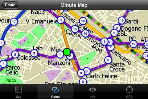
Rome Metro by Zuti - The "Rome Metro" application is a superb geographically based map and route planner for the Rome Metro, Tram, Urban and Regional rail systems. This application is one in a worldwide series of Zuti maps from Visual IT who have been producing public transportation maps for mobile devices for many years.
MAP
The map is hand drawn by Visual IT and provides a unique geographically based view of the city with many places of interest drawn directly on the background so you can easily get your bearings when traveling in and around the city. You can also use your inbuilt GPS (can also work with iPod Touch devices) to accurately locate and track yourself within the city centre and see the nearest transportation stop and distance to it. This is the only pubic transportation route planner with this ability.
Tap on the map for location information, use the inbuilt search feature or choose from a list of locations. Places of interest, museums, hotels, parks, restaurant, shops, hospitals, streets, etc, are also included. The route planner will automatically suggest the nearest station to any place of interest you select.
NO INTERNET CONNECTION REQUIRED
The map and routing does not require an internet connection and you will not be charged data connection fees. This also means the application runs successfully underground and on an iPod Touch. The only feature that requires an internet data connection is the “Live Info” which is optional and if used only requires a small amount of data.
ROUTING
Does not require an internet connection and will always be available to display a clear and detailed view of the city transport systems, plus list and animate the optimum route for your journey. Provides the fastest route calculations of any mobile routing application (virtually instantaneous) using actual published journey times with the ability to select the quickest route or the route with the least changes.
Comprehensive details of your planned route are provided, including changes, directions of travel, number of stops, predicted journey times, etc. Uniquely this application gives you “direction”, “towards” and “service frequency” information (not available on any other offline journey planner) for example “Take the Red line (Southbound) towards 95th/Dan Ryan for 6 stops. Service runs every 7 minutes” which is essential when finding the correct platform and connection. Also given are alternatives for each leg of the journey.
What's New in This Release:
· New map and routing.
· Improved "Travel Explorer" mode.
What's New in 1.4:
· Support for retina display
· New "Measure Tool"
· Bug fix for iOS 5
What's New in 1.3:
· Updated map and routes.
· Faster map loading.
· New route description text and layout.
· New "Take me home" option.
· New "Recent routes" option.
· Various other minor updates and improvements.
Like it? Share with your friends!
If you got an error while installing Themes, Software or Games, please, read FAQ.
Supported operating systems:
Apple iOS 10.x (iPad), Apple iOS 10.x (iPhone), Apple iOS 11.x (iPad), Apple iOS 12.x (iPad), Apple iOS 12.x (iPhone), Apple iOS 4.0.x (iPhone), Apple iOS 4.0.x (iPod Touch), Apple iOS 4.2.x (iPad), Apple iOS 4.2.x (iPhone), Apple iOS 4.2.x (iPod Touch), Apple iOS 4.3.x (iPad), Apple iOS 4.3.x (iPhone), Apple iOS 4.3.x (iPod Touch), Apple iOS 5.0 (iPad), Apple iOS 5.0 (iPhone), Apple iOS 5.0 (iPod Touch), Apple iOS 6.0 (iPad), Apple iOS 6.0 (iPhone), Apple iOS 6.0 (iPod Touch), Apple iOS 7.0 (iPad), Apple iOS 7.0 (iPhone), Apple iOS 7.0 (iPod Touch), Apple iOS 8.x (iPad), Apple iOS 8.x (iPhone), Apple iOS 8.x (iPod Touch), Apple iOS 9.x (iPad), Apple iOS 9.x (iPhone), Apple iOS 9.x (iPod Touch), Apple iPhone OS 3.1.x, Apple iPhone OS 3.1.x (iPod Touch), Apple iPhone OS 3.2.x (iPad)
Similar Software:
Asian Food Finder Asian Food is an easy-to-use, quick, and convenient way to find an Asian restaurant near you
Barcelona Metro for iPad by Zuti Barcelona Metro for iPad by Zuti - This Zuti application contains a visually unique map of the Barcelona transport system and a superb animated journey planner to help you get around the TMB (Transports Metropolitan de Barcelona), FGC (Ferrocarrils de la Generalitat de Catalunya) Metro and Tram services
Detroit Maps Detroit Maps software that helps you download and store the travel maps and plans you need. This super-handy app lets you download publicly available maps and store them on your iPhone or iPod Touch. You can download the maps when you have fast wifi connection - and then use any time in the future without delay
New York Subway 10 for iPad New York Subway 10 - The “New York Subway” application is a superb geographically based map and route planner for the New York public transport systems
Barcelona Metro 10 for iPad Barcelona Metro 10 - This Zuti application contains a visually unique map of the Barcelona transport system and a superb animated journey planner to help you get around the TMB (Transports Metropolitan de Barcelona), FGC (Ferrocarrils de la Generalitat de Catalunya) Metro and Tram services
Bus: Gold Coast Bus: Gold Coast is a friendly timetable application that provides bus timetable for Gold Coast bus transport commuters. If you need an application to keep track of your favourite bus timetables in Gold Coast then this is for you!
· Access to timetables in Gold Coast, Australia.
· Save and remove favourite routes at the touch of a button
Vancouver Family Fun Vancouver Family Fun - Looking for the perfect family outing in Vancouver? Need a Vancouver restaurant that will feed both you and your kids? Not sure what to do with the family for the day? Then look no further. The Vancouver Family Fun application is filled with exciting attractions, child friendly restaurants and museums that will engage kids of all ages
Beijing Subway by Zuti Beijing Subway by Zuti - The new Beijing Metro 10 map makes it easy to travel in and around the city using the Metro, Batong line, Airport Express line and Suburban S2 lines services
Rome Metro 10 for iPad Rome Metro 10 -The Zuti Rome Metro application is a superb geographically based map and route planner for the Metro, Tram, Urban and Regional rail systems. Unlike old fashioned schematic style maps this product contains a geographically accurate central area showing major streets, parks and places of interest etc, allowing the user to easily get their bearings
Phoenix Maps Phoenix Maps - software that helps you download and store the travel maps and plans you need. This super-handy application lets you download publicly available maps and store them on your iPhone or iPod Touch. You can download the maps when you have fast wifi connection - and then use any time in the future without delay
Other Software by developer «Visual IT»:
Tube 2 Miami (Palm OS) Tube 2 Miami (Palm OS) - This map package for Tube 2 consists of a fully scrollable detailed map of the Miami metro & rail system.
Plan journeys on this system, list details of the quickest routes and see a superb animated display of your journey tracking around the system map
Beijing Subway for iPad by Zuti Beijing Subway for iPad by Zuti - Beijing Metro map makes it easy to travel in and around the city using the Beijing metro system and also includes the S2 rail line to the Great Wall at Badaling
Tube 2 Washington Pro (Palm OS) Tube 2 Washington Pro (Palm OS) - This map package for Tube 2 consists of a fully scrollable detailed map of the Washington D.C. metro system and linked high quality street maps of central Washington D.C.
Plan journeys on the metro system, list details of the quickest routes and see a superb animated display of your journey tracking around the system map
Tube 2 Engine (UIQ) Tube 2 Engine (UIQ) - Transform your phone into a fully scrollable detailed map of one of the worlds subway or metro systems.
See your journeys come alive with a superb animated display.
Save hours by automatically having the quickest routes to hand, with all the details you need including line changes, platform directions and accurate journey times
Tube Munich (UIQ) Tube Munich (UIQ) - An award winning and highly acclaimed application that guides you around the complex metro (S-Bahn / U-Bahn) system of Munich.
An essential addition to your P800 / P900 / P910 if if you travel in or around this city
· A detailed clear colour map of the Munich metro (S-Bahn / U-Bahn) system fully scrollable.
· Quick find station utility
Tube Singapore (Series 60) Tube Singapore (Series 60) - Our highly acclaimed Tube application that guides you around the metro system of Singapore is now available for your Series 60 Symbian powered phone. An essential addition to your phone for locals and tourists alike.
· A detailed clear colour map of the Singapore metro system fully scrollable.
· Quick find station utility
London Jubilee Walkway Guide (UIQ) London Jubilee Walkway Guide (UIQ) - Essential guide to the Jubilee Walkway, London's premier walking trail. Using full colour interactive maps designed to connect the majority of London's key attractions. It is well managed, easy to follow and provides an ideal way of getting to know London
Tube London (2009 Edition) Tube London (2009 Edition) - Tube London
The ideal map for the traveller who needs to get around London using the underground system and would like to know just exactly where they are.
The map geographically locates all the central stations, making it much more informative than the official topological map
Tube 2 Dublin (UIQ) Tube 2 Dublin (UIQ) - This map package for Tube 2 consists of a fully scrollable detailed map of the Dublin rail system.
Plan journeys on this system, list details of the quickest routes and see a superb animated display of your journey tracking around the system map
TUBE 2 Amsterdam Pro TUBE 2 Amsterdam Pro - This map package for Tube 2 consists of a fully scrollable detailed map of the Amsterdam tram & metro system and linked street maps of central Amsterdam.
Plan journeys on the tram & metro system, list details of the quickest routes and see a superb animated display of your journey tracking around the system map

")


")

")
")
")
")
")
")
")
