Marine: Oslo Fjord HD - GPS Map Navigator - FlytoMap provides complete, quick and easy to use map applications for navigation for iPad. Continues in the tradition of offering depth of information and functionality across expected places all over the world, exploring the map you get maximum details obtaining detailed information of every object on the map.
FlytoMap processes different types of maps for navigation for different categories:
WATER MAPS (Marine):
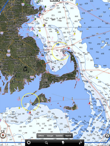
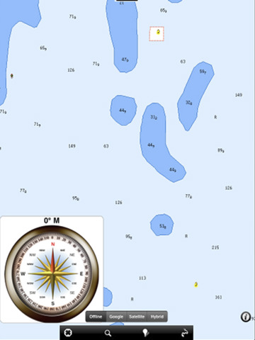
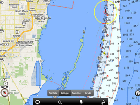
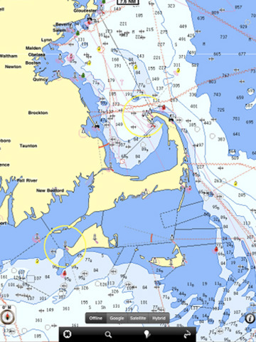
Water map navigator is the new ‘Marine Navigator for iPad.’ Contains embedded Electronic Nautical Charts (ENC) from NOAA compressed to a large coverage. You can now download the application and transform your iPad in a chart plotter with best NOAA, ENC S57 cartography; which includes Anchoring areas, Fishing areas, restriction areas, obstructions, rocks, Buoys, Beacons, Lights, Depth contours with Values display on map, Spot Soundings and more. The only marine app available in the market with such huge information. Every effort is made to be as accurate as possible when presenting information for every destination.
PARK MAPS:
Park map applications are extremely advanced contains embedded electronic charts with all information collected from the National Park Service and local sources. The maps contain all multiple trails (Hiking, biking, Stairway trails, Bicycle trails, Equestrian trails etc.,) and Point of interests (POI) like Campgrounds, Eating places, Ranger Stations, Picnic areas, Boat/Canoe launching, Parking areas etc., which are provided depending on the relevant park areas they exist.
LAKE MAPS:
We offer high quality lake maps with detailed information and important features compressed to assure the larger coverage in USA region. Lake maps contain most important DNR lakes with detailed ‘Depth Contours, Boat Ramps, Fishing spots etc. Also includes Trails, Roads and Railways information.
TRAVEL MAPS:
These Maps treat you mostly with information of both Marine and terrain correspondingly. These are the most preferable Maps to travel especially for fascinating recreational voyages, map focus the best Beach spots along the Coast line, Major ports, Sailing, Fishing, Picnic areas, Parks, Hiking, Biking, Clubs, restaurants, Famous Hotels, Museums, Shopping areas, and much more.
· Use Latitudes and Longitudes to go to your favorite places
· Insert the target/destination 'Waypoint' and see in real time your speed, distance and direction to destination
· Insert Unlimited Markers near favorite places on the map
· Search your Favorite points directly
· Zoom, Rotate and Pan fast just by a finger touch
· Navigate and see your GPS position on the map
· Geo-Tagged photo management
· Set On/Off Elevation Contours if you feel data is cluttering
What's New in This Release:
· Added the link to the NOAA buoys in the application console.
Like it? Share with your friends!
If you got an error while installing Themes, Software or Games, please, read FAQ.
Supported operating systems:
Apple iOS 10.x (iPad), Apple iOS 11.x (iPad), Apple iOS 12.x (iPad), Apple iOS 4.2.x (iPad), Apple iOS 4.3.x (iPad), Apple iOS 5.0 (iPad), Apple iOS 6.0 (iPad), Apple iOS 7.0 (iPad), Apple iOS 8.x (iPad), Apple iOS 9.x (iPad)
Thailand Map Thailand Map - This application enables you to use maps offline without internet connection. This includes maps street names detail. This will give peace of mind when traveling aboard knowing you will not be charged with roaming fee. So if you live or travel in that city, it will help you much in your life
Hong Kong Travel Guide - Lonely Planet Our location-aware technology gives you hundreds of handy reviews, striking images and interactive maps - all searchable, portable and easily personalised
Seoul Offline Map Seoul Offline Map - This application enables you to use maps offline without internet connection. This includes maps street names detail. This will give peace of mind when traveling aboard knowing you will not be charged with roaming fee. So if you live or travel in that city, it will help you much in your life
Saint Martin - GPS Map Navigator Saint Martin - GPS Map Navigator - FlytoMap provides complete, quick and easy to use map applications for navigation for iPhone. Continues in the tradition of offering depth of information and functionality across expected places all over the world, exploring the map you get maximum details obtaining detailed information of every object on the map
Sydney Travel Guide - Lonely Planet Our location-aware technology gives you hundreds of handy reviews, striking images and interactive maps - all searchable, portable and easily personalised
Sao Paulo Walking Tours and Map Sao Paulo Walking Tours and Map - No need to hop on a tour bus or join a group; now you can explore all the best attractions on your own, at your own pace, and at a cost that is only a fraction of what you would normally pay for a guided tour
Paris Map and Walking Tours Paris Map and Walking Tours - No need to hop on a tour bus or join a group; now you can explore all the best attractions on your own, at your own pace, and at a cost that is only a fraction of what you would normally pay for a guided tour
Dubai Map and Walking Tours Dubai Map and Walking Tours - This Lite version of the walking tours application comes with a detailed and fully functional city map to assist you explore the city and locate sights. City map functions in this app include: street name and business (restaurants, cafes, etc
Other Software by developer «Flytomap»:
Comoros Islands HD - GPS Map Navigator Comoros Islands HD - GPS Map Navigator - FlytoMap provides complete, quick and easy to use map applications for navigation for iPad. Continues in the tradition of offering depth of information and functionality across expected places all over the world, exploring the map you get maximum details obtaining detailed information of every object on the map
Lake Mead - Fishing Lake Mead - Fishing - Lake Mead offers year round recreational opportunities. Lake delights to boaters, swimmers, fishermen and wildlife viewers. Lake Mead is the 16th largest man made lake in the world. It occupies about 1.5 million acres and about 820 miles of shoreline
Acadia National Park - Standard Acadia National Park - Standard - FlytoMap provides complete, quick and easy to use map applications for navigation for iPhone. Continues in the tradition of offering depth of information and functionality across expected places all over the world, exploring the map you get maximum details obtaining detailed information of every object on the map
North York Moors National Park - GPS Map Navigator North York Moors National Park - GPS Map Navigator - FlytoMap provides complete, quick and easy to use map applications for navigation for iPhone. Continues in the tradition of offering depth of information and functionality across expected places all over the world, exploring the map you get maximum details obtaining detailed information of every object on the map
Marine: Mediterranean Sea HD - GPS Map Navigator Marine: Mediterranean Sea HD - GPS Map Navigator - FlytoMap provides complete, quick and easy to use map applications for navigation for iPad. Continues in the tradition of offering depth of information and functionality across expected places all over the world, exploring the map you get maximum details obtaining detailed information of every object on the map
Mount Ranier National Park - Standard Mount Ranier National Park - Standard - Continues in the tradition of offering depth of information and functionality across expected places all over the world, exploring the map you get maximum details obtaining detailed information of each object on the map
Kellerwald-Edersee National Park - GPS Map Navigator Kellerwald-Edersee National Park - GPS Map Navigator - FlytoMap provides complete, quick and easy to use map applications for navigation for iPhone. Continues in the tradition of offering depth of information and functionality across expected places all over the world, exploring the map you get maximum details obtaining detailed information of every object on the map
Marine : Cote d'Azur - GPS Map Navigator Marine : Cote d'Azur - GPS Map Navigator - FlytoMap provides complete, quick and easy to use map applications for navigation for iPhone. Continues in the tradition of offering depth of information and functionality across expected places all over the world, exploring the map you get maximum details obtaining detailed information of every object on the map
Bali - GPS Map Navigator Bali - GPS Map Navigator. FlytoMap provides complete, quick and easy to use map applications for navigation for iPhone. Continues in the tradition of offering depth of information and functionality across expected places all over the world, exploring the map you get maximum details obtaining detailed information of every object on the map
Mille Lacs Lake - Fishing Mille Lacs Lake - Fishing - Mille Lacs Lake is Minnesota's second largest inland lake. Relatively shallow, the large lake is one of many glacial pothole lakes in the area 100 miles west of Duluth.
Mille Lacs Lake shines especially for fishing activities

")