Great Britain Rail for iPad by Zuti - The new Great Britain Rail map makes it easy to travel in and around the country using the rail services. This application contains a geographically accurate map of the whole of Great Britain allowing you to easily view the route of any journey. The routing and map are contained within the application and no internet connection is required to use these features.
MAP
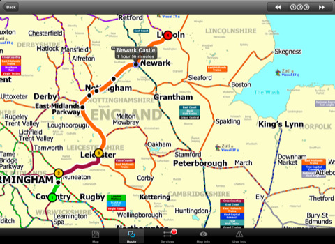
The map is hand drawn by Visual IT and provides a unique geographically based view of the Great Britain rail system. You can also use your inbuilt GPS to accurately locate and track yourself and see the nearest transportation stop and distance to it. This is the only rail transportation route planner with this ability. Tap on the map for location information, use the inbuilt search feature or choose from a list of locations.
MINUTE MAP
Another unique feature is the “Minute Map” option which allows you to see the travel times from a start point to all other locations on the map. This is a great way to view the topology of the country and gauge traveling times.
ROUTING
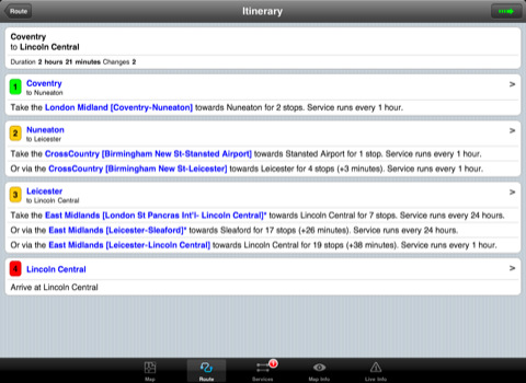
The application does not require an internet connection for routing and will always be available to display a clear and detailed view of the various rail operating company systems, plus list and animate the optimum route for your journey. This product provides the fastest route calculations of any mobile routing application using actual published journey times with the ability to select the quickest route or the route with the least changes.
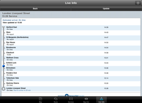
LIVE INFO
When an internet connection is available the user can check train arrivals and departures with live data supplied by National Rail Enquiries. Also shown is the estimated current real time position of the train for any of the listed services.
· The only rail app with a rail map.
· Full offline map and routing, works anywhere, no internet connection required.
· Designed for the first time visitor and experienced commuter.
· Simple, fast and intuitive to use.
· Colourful clear custom drawn geographically accurate mapping.
· Animates the route and allows tracking of the journey using GPS.
· Instantly see the route of any transport service drawn on the map.
· Save and recall favourite and recent journeys.
· One touch take me home feature.
· Unique "Minute Map" feature allows quick view of all journey times from a start location.
· Services can be turned on or off, routing round problems.
· Works on any iPad with iOS 3.2 or above.
· GPS location and tracking.
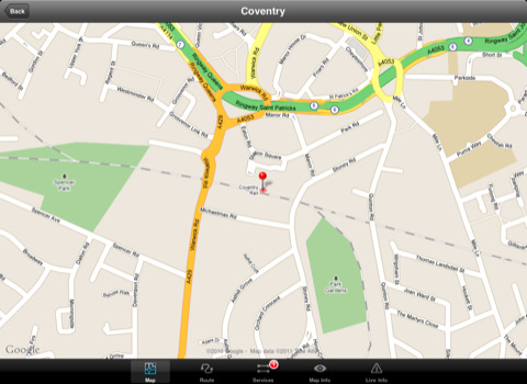
· View station locations on a Google map (internet required).
· View Live train departures and arrivals (internet required, live data supplied by National Rail Enquiries).
Like it? Share with your friends!
If you got an error while installing Themes, Software or Games, please, read FAQ.
Supported operating systems:
Apple iOS 10.x (iPad), Apple iOS 11.x (iPad), Apple iOS 12.x (iPad), Apple iOS 4.2.x (iPad), Apple iOS 4.3.x (iPad), Apple iOS 5.0 (iPad), Apple iOS 6.0 (iPad), Apple iOS 7.0 (iPad), Apple iOS 8.x (iPad), Apple iOS 9.x (iPad), Apple iPhone OS 3.2.x (iPad)
Similar Software:
Trip Planner Pro Trip Planner Pro - Trip Planner by GPSmyCity is a handy tool for planning your daily activities.
You can create daily itineraries for your trip, write down notes, track activities, and share your activity details with your friends. This application keeps all your travel details at your fingertips
New York Subway 10 for iPad New York Subway 10 - The “New York Subway” application is a superb geographically based map and route planner for the New York public transport systems
Bremerhaven World Travel Bremerhaven World Travel - map with locate me function makes you free to move.
Background reading always accompanies you on your trip
TripIt No Ads for iPhone/iPad TripIt No Ads for iPhone/iPad - TripIt is is a useful app which organizes your travel plans into an itinerary that has all the details of your trip in one place. Simply forward airline, car rental, hotel and restaurant reservations to TripIt, and you will be able to access them from anywhere
HotelPal Download HotelPal for FREE to browse and book from over 100,000 hotels worldwide. Live rate availability, full-screen photos and in-app booking make hotel reservations a breeze. HotelPal is the easiest way to reserve hotels for road trips, last-minute plans, cancelled flights and more, with no hotel booking fees.
· Search available hotels by city, zip or GPS
Bars & Clubs Bars & Clubs is an easy-to-use, quick, and convenient way to find a bar or night club near you.
Bars & Clubs quickly identifies your location and lets you choose the nearest Local Bar, Pub, Lounge, Sports Bar, Wine Bar, Billiard Bar, Brewery, Comedy Club, etc..
Phoenix Maps Phoenix Maps - software that helps you download and store the travel maps and plans you need. This super-handy application lets you download publicly available maps and store them on your iPhone or iPod Touch. You can download the maps when you have fast wifi connection - and then use any time in the future without delay
Washington Metro by Zuti Washington Metro by Zuti - The new Washington Metro 10 map makes it easy to travel in and around the city using the WMATA Metro, MARC and VME systems. Also included are the Potomac river taxi routes and the DC Circulator bus routes
TransitM&S Nashville TransitM&S Nashville - TransitM&S is an easy-to-use transit application that provides bus info for Nashville's MTA.
The app is designed for offline use. It is ideal for iPod Touch users. Even for iPhone users, it is designed to save money because AT&T no longer offers the unlimited data plan
Chicago Maps Chicago Maps - This super-handy app lets you download publicly available maps and store them on your iPhone or iPod Touch. You can download the maps when you have fast wifi connection - and then use any time in the future without delay. Transit Train and Street maps, as well as tourist guides to help you around the city
Other Software by developer «Visual IT»:
Tube 2 London Streets (Palm OS) Tube 2 London Streets (Palm OS) - This map package for Tube 2 consists of a fully scrollable detailed map of the London Underground system and 9 linked A-Z street maps.
Plan journeys on the London Underground system, list details of the quickest routes and see a superb animated display of your journey tracking around the system map
Tube 2 New York City Pro (UIQ3) Tube 2 New York City Pro (UIQ3) - This map package for Tube 2 consists of a fully scrollable detailed map of the New York City MTA subway system and linked high quality street maps of Manhattan. Also included are additional reference maps of the rail systems surrounding NYC
Tube 2 Madrid Pro (UIQ3) Tube 2 Madrid Pro (UIQ3) - This map package for Tube 2 consists of a fully scrollable detailed map of the Madrid metro system and linked street maps of central Madrid.
Plan journeys on the metro system, list details of the quickest routes and see a superb animated display of your journey tracking around the system map
GB Major Road Atlas (UIQ3) GB Major Road Atlas (UIQ3) - This map package is an essential addition to your Tube 2 maps if you drive in and around Great Britain.
This reference map gives you a clear view of all the major roads in the whole of Great Britain, you can use the quick find feature to locate any of the 30,000 + GB towns and villages in the database
Tube 2 Paris Touristic (UIQ) Tube 2 Paris Touristic (UIQ) - This map package for Tube 2 is the ideal map for the tourist or business traveller who needs to get around Paris using the metro system and would like to know just exactly where they are. The map geographically locates all the central stations, making it much more informative than the official topological map
Tube Munich (Palm OS) Tube Munich (Palm OS) - An award winning and highly acclaimed Palm OS application that guides you around the metro (S-Bahn / U-Bahn) system of Munich. An essential addition to your Palm device for locals and tourists alike.
Tube's features include:
A detailed clear colour (or grey scale) map of the transport system fully scrollable.
Quick find station utility
Tube 2 New York City Pro (Palm OS) Tube 2 New York City Pro (Palm OS) - This map package for Tube 2 consists of a fully scrollable detailed map of the New York City MTA subway system and linked high quality street maps of Manhattan. Also included are additional reference maps of the rail systems surrounding NYC
Tube 2 Paris Touristic (Palm OS) Tube 2 Paris Touristic (Palm OS) - This map package for Tube 2 is the ideal map for the tourist or business traveller who needs to get around Paris using the metro system and would like to know just exactly where they are. The map geographically locates all the central stations, making it much more informative than the official topological map
Washington Metro for iPad by Zuti The new Washington Metro 10 map makes it easy to travel in and around the city using the WMATA Metro, MARC and VME systems. Also included are the Potomac river taxi routes and the DC Circulator bus routes
Tokyo Metro for iPad by Zuti Tokyo Metro for iPad by Zuti - Tokyo Metro map makes it easy to travel in and around the city using the Toei Subway, JR East routes (within the Tokyo Suburban area), Shinkansen routes, Streetcars, some important private lines and Tokyo Cruise lines

")


")
")
")
")
")
")
")
")

