Boston Subway for iPad by Zuti - This Boston Subway map makes it easy to travel in and around the city using the MBTA Subway, MBTA Commuter Rail, MBTA Boats, and Massport shuttle buses. Unlike old fashioned schematic style maps this product contains a geographically accurate central area showing major streets, parks and places of interest etc.
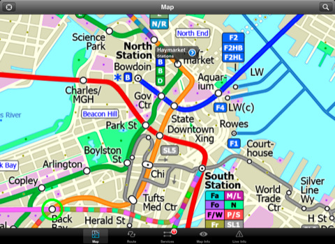
MAP
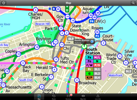
The map is hand drawn by Visual IT and provides a unique geographically based view of Boston with many places of interest drawn directly on the background so you can easily get your bearings when traveling around the city. You can also use your inbuilt GPS to accurately locate and track yourself within the city centre and see the nearest transportation stop and distance to it. This is the only public transportation route planner with this ability.
Tap on the map for location information, use the inbuilt search feature or choose from a list of locations. Places of interest, museums, hotels, parks, restaurant, shops, hospitals, streets, etc, are also included. The route planner will automatically suggest the nearest station to any place of interest you select.
MINUTE MAP
Another great feature is the “Minute Map” option which allows you to see the travel times from a start point to all other locations on the map. This is a unique way to view the topology of a city and gauge traveling times.
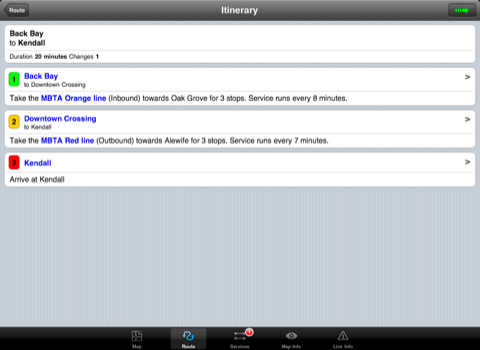
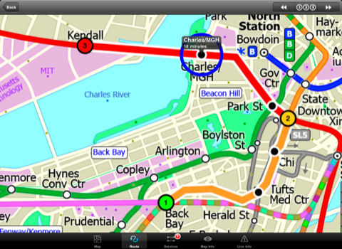
ROUTING
The application does not require an internet connection and will always be available to display a clear and detailed view of the city transport systems, plus list and animate the optimum route for your journey. This product provides the fastest route calculations of any mobile routing application (virtually instantaneous) using actual published journey times with the ability to select the quickest route or the route with the least changes.
LIVE INFO
When an internet connection is available, optional "Live Information" on the current state of the transport services can be viewed, allowing you to plan your journeys in advance and avoid any potential delays. Unique to this application is the ability to turn off services that are out of action and automatically calculate an alternative route.
· Designed for the first time visitor and experienced commuter.
· Simple, fast and intuitive to use.
· Full offline map and routing, works underground, no internet connection required.
· Animates the route and allows tracking of the journey using GPS
· Instantly see the route of any transport service drawn on the map.
· Save and recall favourite and recent journeys.
· Take me home feature.
· Unique "Minute Map" feature allows quick view of all journey times from a start location.
· Services can be turned on or off, routing round problems.
· Works in landscape or portrait mode.
· GPS location and tracking.
· Streets, Places of interest etc built into the application.
· View locations on a Google map.
· Live service status, planned disruptions, etc (internet required).
Like it? Share with your friends!
If you got an error while installing Themes, Software or Games, please, read FAQ.
Supported operating systems:
Apple iOS 10.x (iPad), Apple iOS 11.x (iPad), Apple iOS 12.x (iPad), Apple iOS 4.2.x (iPad), Apple iOS 4.3.x (iPad), Apple iOS 5.0 (iPad), Apple iOS 6.0 (iPad), Apple iOS 7.0 (iPad), Apple iOS 8.x (iPad), Apple iOS 9.x (iPad), Apple iPhone OS 3.2.x (iPad)
Similar Software:
FlightTrack FlightTrack - The best flight tracking app out there. Track every aspect of your domestic and international flights with real-time updates and beautiful, zoomable maps. Check gate numbers, delays and cancellations
Catania World Travel Catania World Travel - Map with locate me function makes you free to move.
Background reading always accompanies you on your trip
Tuscany for Foodies Tuscany for Foodies - Tuscany for Foodies introduces you to the best of foodie Tuscany, from the butchers, bakers, and cheese makers who adhere to ancient traditions and proudly sell their goods in small shops, to restaurants large and small that process local ingredients into good-to-eat meals
London City Maps London City Maps -software that helps you download and store the travel maps and plans you need. This super-handy app lets you download publicly available maps and store them on your iPhone or iPod Touch. You can download the maps when you have fast wifi connection - and then use any time in the future without delay
Minneapolis Maps Minneapolis Maps -software that helps you download and store the travel maps and plans you need. This super-handy app lets you download publicly available maps and store them on your iPhone or iPod Touch. You can download the maps when you have fast wifi connection - and then use any time in the future without delay
Hotels.com for iPhone Hotels.com for iPhone - Hotels.com allows you to quickly find a hotel and book a room right from your iPhone. The app includes a database of more than 150,000 hotels from 200 countries, complete with photos, ratings and reviews from customers.
The application allows you to search for hotels nearby or at the specified destination, and view their location on a map
ebookers for iPhone/iPad ebookers for iPhone/iPad - ebookers provides an easy way to find and book hotels right from your iPhone. The app includes a database of thousands of places to stay from all over the world, complete with photos, ratings and reviews from customers.
ebookers uses GPS to show you all the hotels nearby
HotelPal Download HotelPal for FREE to browse and book from over 100,000 hotels worldwide. Live rate availability, full-screen photos and in-app booking make hotel reservations a breeze. HotelPal is the easiest way to reserve hotels for road trips, last-minute plans, cancelled flights and more, with no hotel booking fees.
· Search available hotels by city, zip or GPS
Ostrovok.ru Ostrovok.ru provides Russian consumers with hotel booking services and is Russia’s fastest-growing online travel company.
The Ostrovok.ru team is staffed with marketing, travel and technology professionals from leading ecommerce companies: Yandex, Google, Booking.com, Groupon and others
Plane Finder HD for iPad Plane Finder HD for iPad - Plane Finder is a flight tracker that shows real-time air traffic on a 2D map.
Tap on a plane to view airline, flight number, route, speed and altitude, aircraft information, departure and arrival data, etc.
The app allows you to search for more than 12,000 aircraft, which are tracked in real-time using ADS-B data
Other Software by developer «Visual IT»:
London Congestion Charge Map (UIQ3) London Congestion Charge Map (UIQ3) - This map package is an essential addition to your Tube 2 maps if you drive in or around central London.
This reference map gives you a clear view of the area now covered by the congestion charge system, complete with a quick find utility to help you find any major road or street in and around the area
Tube 2 Chicago (UIQ) Tube 2 Chicago (UIQ) - This map package for Tube 2 consists of a fully scrollable detailed map of the Chicago metro & commuter rail system.
It includes the rapid transport system of subway and elevated lines, in addition to the many commuter rail lines. The map also indicates how the Amtrak intercity routes intersect with the cities transport network
Tube Montreal (Palm OS) Tube Montreal (Palm OS) - An award winning and highly acclaimed Palm OS application that guides you around the metro system of Montreal. An essential addition to your Palm device for locals and tourists alike.
Tube's features include:
A detailed clear colour map of the Montreal metro system fully scrollable.
Quick find station utility
Tube Munich (UIQ) Tube Munich (UIQ) - An award winning and highly acclaimed application that guides you around the complex metro (S-Bahn / U-Bahn) system of Munich.
An essential addition to your P800 / P900 / P910 if if you travel in or around this city
· A detailed clear colour map of the Munich metro (S-Bahn / U-Bahn) system fully scrollable.
· Quick find station utility
Tube Nottingham Streets Tube Nottingham Streets - A complete street map of central Nottingham for your Palm device using superb map tiles from the famous A-Z map company.
These maps plug directly into our new Tube engine and are a convenient replacement for your paperback A-Z. Never get lost in Nottingham again
Tube 2 New York City Pro (UIQ) Tube 2 New York City Pro (UIQ) - This map package for Tube 2 consists of a fully scrollable detailed map of the New York City MTA subway system and linked high quality street maps of Manhattan. Also included are additional reference maps of the rail systems surrounding NYC
Tube 2 Paris Touristic (UIQ3) Tube 2 Paris Touristic (UIQ3) - This map package for Tube 2 is the ideal map for the tourist or business traveller who needs to get around Paris using the metro system and would like to know just exactly where they are. The map geographically locates all the central stations, making it much more informative than the official topological map
Tube 2 Seoul (UIQ) Tube 2 Seoul (UIQ) - This map package for Tube 2 consists of a fully scrollable detailed map of the Seoul Metropolitan Subway system.
Plan journeys on this system, list details of the quickest routes and see a superb animated display of your journey tracking around the system map
Rough Guides Map New York City Rough Guides Map New York City... These guides are a series of fantastic interactive maps.
Produced in conjunction with the premier travel publisher Rough Guides.
Discover and explore New York City using full colour interactive linked maps, in this simple to use PDA version of The Rough Guides New York City
Tyne & Wear Metro for iPad by Zuti Tyne & Wear Metro for iPad by Zuti - The new Tyne & Wear Metro map makes it easy to travel in and around the city using the Nexus Metro system. Unlike old fashioned schematic style maps this product contains a geographically accurate central area showing major streets, parks and places of interest etc, allowing the user to easily get their bearings


")
")
")
")

")
")
")

