Platforms: iPhone, iPad, iPod Touch, Apple iPhone OS
Categories: Travel & Navigation
Upload date: 11 Jul 13
Developer: Visual IT
License: Commercial
Price: 2.99 $
Downloads: 35
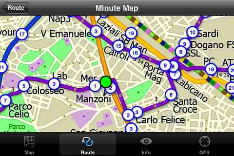
Rome Metro by Zuti - The "Rome Metro" application is a superb geographically based map and route planner for the Rome Metro, Tram, Urban and Regional rail systems. This application is one in a worldwide series of Zuti maps from Visual IT who have been producing public transportation maps for mobile devices for many years.
MAP
The map is hand drawn by Visual IT and provides a unique geographically based view of the city with many places of interest drawn directly on the background so you can easily get your bearings when traveling in and around the city. You can also use your inbuilt GPS (can also work with iPod Touch devices) to accurately locate and track yourself within the city centre and see the nearest transportation stop and distance to it. This is the only pubic transportation route planner with this ability.
Tap on the map for location information, use the inbuilt search feature or choose from a list of locations. Places of interest, museums, hotels, parks, restaurant, shops, hospitals, streets, etc, are also included. The route planner will automatically suggest the nearest station to any place of interest you select.
NO INTERNET CONNECTION REQUIRED
The map and routing does not require an internet connection and you will not be charged data connection fees. This also means the application runs successfully underground and on an iPod Touch. The only feature that requires an internet data connection is the “Live Info” which is optional and if used only requires a small amount of data.
ROUTING
Does not require an internet connection and will always be available to display a clear and detailed view of the city transport systems, plus list and animate the optimum route for your journey. Provides the fastest route calculations of any mobile routing application (virtually instantaneous) using actual published journey times with the ability to select the quickest route or the route with the least changes.
Comprehensive details of your planned route are provided, including changes, directions of travel, number of stops, predicted journey times, etc. Uniquely this application gives you “direction”, “towards” and “service frequency” information (not available on any other offline journey planner) for example “Take the Red line (Southbound) towards 95th/Dan Ryan for 6 stops. Service runs every 7 minutes” which is essential when finding the correct platform and connection. Also given are alternatives for each leg of the journey.
What's New in This Release:
· New map and routing.
· Improved "Travel Explorer" mode.
What's New in 1.4:
· Support for retina display
· New "Measure Tool"
· Bug fix for iOS 5
What's New in 1.3:
· Updated map and routes.
· Faster map loading.
· New route description text and layout.
· New "Take me home" option.
· New "Recent routes" option.
· Various other minor updates and improvements.
Like it? Share with your friends!
If you got an error while installing Themes, Software or Games, please, read FAQ.
Supported operating systems:
Apple iOS 10.x (iPad), Apple iOS 10.x (iPhone), Apple iOS 11.x (iPad), Apple iOS 12.x (iPad), Apple iOS 12.x (iPhone), Apple iOS 4.0.x (iPhone), Apple iOS 4.0.x (iPod Touch), Apple iOS 4.2.x (iPad), Apple iOS 4.2.x (iPhone), Apple iOS 4.2.x (iPod Touch), Apple iOS 4.3.x (iPad), Apple iOS 4.3.x (iPhone), Apple iOS 4.3.x (iPod Touch), Apple iOS 5.0 (iPad), Apple iOS 5.0 (iPhone), Apple iOS 5.0 (iPod Touch), Apple iOS 6.0 (iPad), Apple iOS 6.0 (iPhone), Apple iOS 6.0 (iPod Touch), Apple iOS 7.0 (iPad), Apple iOS 7.0 (iPhone), Apple iOS 7.0 (iPod Touch), Apple iOS 8.x (iPad), Apple iOS 8.x (iPhone), Apple iOS 8.x (iPod Touch), Apple iOS 9.x (iPad), Apple iOS 9.x (iPhone), Apple iOS 9.x (iPod Touch), Apple iPhone OS 3.1.x, Apple iPhone OS 3.1.x (iPod Touch), Apple iPhone OS 3.2.x (iPad)
Similar Software:
London Tube for iPad by Zuti London Tube for iPad by Zuti - "London Tube 10" is a superb geographically based map and route planner for the London Underground, Overground, Docklands Light Railway (DLR), Croydon Tramlink and London Airport Express services
Washington Metro by Zuti Washington Metro by Zuti - The new Washington Metro 10 map makes it easy to travel in and around the city using the WMATA Metro, MARC and VME systems. Also included are the Potomac river taxi routes and the DC Circulator bus routes
TransitM&S Nashville TransitM&S Nashville - TransitM&S is an easy-to-use transit application that provides bus info for Nashville's MTA.
The app is designed for offline use. It is ideal for iPod Touch users. Even for iPhone users, it is designed to save money because AT&T no longer offers the unlimited data plan
TransitGuru Halifax The only transit app that combines with offline schedule, system maps, multiple transit types (train or bus) or agencies for single metro area, alarm to wake you up when arrival, and integration with Yelp and Map
Berlin Metro by Zuti Berlin Metro by Zuti - The new Berlin Metro map makes it easy to travel in and around the city using the Metro (U-Bahn) Suburban Rail (S-Bahn) and Tram (MetroTram and Straßenbahn) systems
Booking.com for iPhone/iPad 6.0. Booking.com for iPhone/iPad 6.0. - Booking.com allows you to quickly find and book hotels right from your iPhone, iPad or iPod touch. The app includes a database of more than 250,000 places to stay from all over the world, along with over 17 million guest reviews and more than 2.6 million hotel photos.
With Booking
Atlanta Maps Atlanta Maps - software that helps you download and store the travel maps and plans you need. This super-handy app lets you download publicly available maps and store them on your iPhone or iPod Touch. You can download the maps when you have fast wifi connection - and then use any time in the future without delay
FlightTrack FlightTrack - The best flight tracking app out there. Track every aspect of your domestic and international flights with real-time updates and beautiful, zoomable maps. Check gate numbers, delays and cancellations
Fuerth World Travel Fuerth World Travel - Map with locate me function makes you free to move.
Background reading always accompanies you on your trip
Other Software by developer «Visual IT»:
Tube 2 Brussels (UIQ) Tube 2 Brussels (UIQ) - This map package for Tube 2 consists of a fully scrollable detailed map of the Brussels tram, metro & bus system.
Plan journeys on these systems, list details of the quickest routes and see a superb animated display of your journey tracking around the system map
Rough Guides Map Rome Rough Guides Map Rome... These guides are a series of fantastic interactive maps.
Produced in conjunction with the premier travel publisher Rough Guides.
Discover and explore Rome using full colour interactive linked maps, in this simple to use PDA version of The Rough Guides Rome
Tube 2 New York Geo (UIQ) Tube 2 New York Geo (UIQ) - This superb map package for Tube 2 is the ideal map for anyone who needs to get around New York City using the MTA subway system and would like to know just exactly where they are.
The map geographically accurately locates all of Manhattans central stations, overlaid onto a street map
Tube 2 Los Angeles (UIQ3) Tube 2 Los Angeles (UIQ3) - This map package for Tube 2 consists of a fully scrollable detailed map of the Los Angeles rail system.
Plan journeys on this system, list details of the quickest routes and see a superb animated display of your journey tracking around the system map
London Bus for iPad by Zuti London Bus for iPad by Zuti - The new Zuti London Bus map has finally arrived, making it easy to travel by bus anywhere in central London. This clear and colourful map covers a detailed street level area of 6 miles by 4 miles and includes over 1300 bus stops and 189 bus routes
Madrid Metro for iPad by Zuti Madrid Metro for iPad by Zuti - Madrid Metro map makes it easy to travel in and around the city using the the Metro, Renfe Rail and Metro Ligero Rail services. Unlike old fashioned schematic style maps this product contains a geographically accurate central area showing major streets, parks and places of interest etc, allowing the user to easily get their bearings
Tube 2 Budapest (Palm OS) Tube 2 Budapest (Palm OS) - This map package for Tube 2 consists of a fully scrollable detailed map of the Budapest metro system and HEV suburban railway.
Plan journeys on this system, list details of the quickest routes and see a superb animated display of your journey tracking around the system map
Tube 2 Munich (UIQ) Tube 2 Munich (UIQ) - This map package for Tube 2 consists of a fully scrollable detailed map of the Munich metro, rail & tram system.
Plan journeys on this system, list details of the quickest routes and see a superb animated display of your journey tracking around the system map.
Munich is the capital city of Bavaria, the southern most German federal state
Tube 2 Paris Touristic (UIQ3) Tube 2 Paris Touristic (UIQ3) - This map package for Tube 2 is the ideal map for the tourist or business traveller who needs to get around Paris using the metro system and would like to know just exactly where they are. The map geographically locates all the central stations, making it much more informative than the official topological map
Rough Guides Map Amsterdam Rough Guides Map Amsterdam... These guides are a series of fantastic interactive maps.
Produced in conjunction with the premier travel publisher Rough Guides.
Discover and explore Amsterdam using full colour interactive linked maps, in this simple to use PDA version of The Rough Guides Amsterdam


")

")
")


")
")
")
