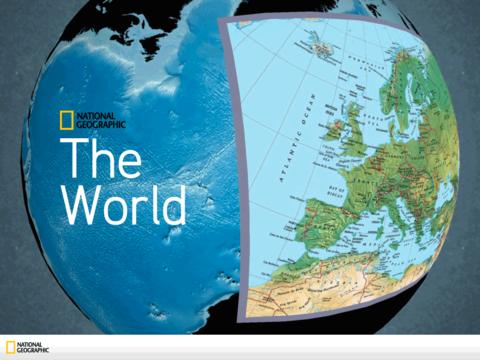
The World by National Geographic - Exclusively designed to leverage features and functionality for the iPad, The World by National Geographic provides one-touch access to locations worldwide. This multi-dimensional application takes National Geographic's award-winning cartography to a new level! Grab hold of the ultra-interactive globe and spin, rotate, zoom, and select to begin your exploration then tell friends about your favorite world views through the app's share features. Navigate entire atlases, hundreds of National Geographic photographs and archives of Country-based data anywhere, anytime with a touch of a finger.
· 3D spinning globe that allows for multi-touch and multi-directional manipulation of worldwide and regional views
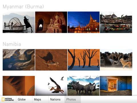
· Hundreds of photographs in featured galleries from National Geographic and My Shot Community photographers
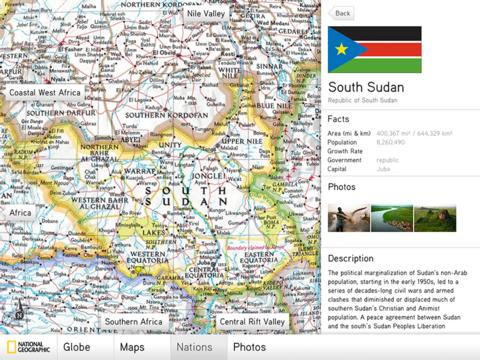
· Hierarchical geography navigation structure based on actual National Geographic products and atlases
· High resolution map layers that allow for detailed zooming
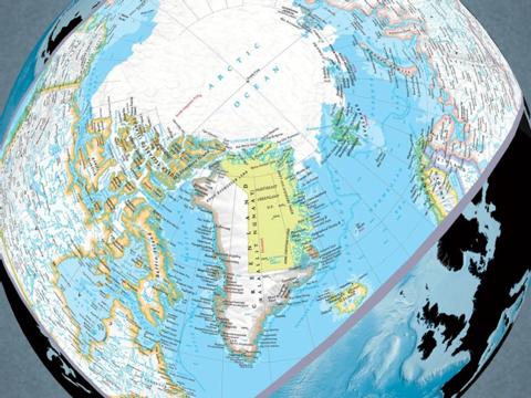
· Accurate and interactive views of the polar regions (a first for a globe of this kind)
· Gallery views of Flags, Photos, Atlas Maps, and more
· Sharing of your favorite map views via email, Facebook, Twitter
What's New in This Release:
· Improved memory performance of app which reduces crashing situations
· Improved Facebook and Twitter sharing functionality
· Added Tweet message text field when sharing map snapshots to Twitter
· Added 5 ocean floor maps and labels
· Added a "Go To Nation" button to photos
· Many additional stylistic tweaks and bug fixes
Like it? Share with your friends!
If you got an error while installing Themes, Software or Games, please, read FAQ.
Supported operating systems:
Apple iOS 10.x (iPad), Apple iOS 11.x (iPad), Apple iOS 12.x (iPad), Apple iOS 4.2.x (iPad), Apple iOS 4.3.x (iPad), Apple iOS 5.0 (iPad), Apple iOS 6.0 (iPad), Apple iOS 7.0 (iPad), Apple iOS 8.x (iPad), Apple iOS 9.x (iPad)
Similar Software:
Wichita Falls (TX, USA) Map Offline Wichita Falls (TX, USA) Map Offline - This will be perfect when you are traveling and you don't have internet connection. This Offline Maps is not a replacement of Google Maps. It is used when you don't have internet connection and want to use maps
Panama GPS Map Panama GPS Map is a navigation App for the country of Panama. All application features and map data is stored within your iPhone, allowing you to use the app freely without the worry of expensive data charges. Fast, simple user interface with detailed map data allows you to navigate throughout Panama using your iPhone
MapsWithMe Pro for iPhone/iPad MapsWithMe Pro for iPhone/iPad - MapsWithMe allows you to access maps of all the countries in the world while on the go. The maps are based on OpenStreetMap data and work completely offline, without requiring an internet connection
CoPilot Live Premium Sat Nav - UK + ROI CoPilot Live Premium Sat Nav - UK + ROI - CoPilot Live Premium is the essential voice-guided sat navigation app to get you where you need to go, by the way that suits you best.
Detailed street maps of UK and Ireland are stored on-board your iPhone so you don’t need to rely on your mobile connection for navigation or worry about losing directions in coverage dead spots
Toronto Walking Tours and Map Toronto Walking Tours and Map - No need to hop on a tour bus or join a group; now you can explore all the best attractions on your own, at your own pace, and at a cost that is only a fraction of what you would normally pay for a guided tour
London Central Bus 10 for iPad London Central Bus 10 for iPad - The new Zuti London Bus map has finally arrived, making it easy to travel by bus anywhere in central London. This clear and colourful map covers a detailed street level area of 6 miles by 4 miles and includes over 1300 bus stops and 189 bus routes
Amsterdam Travel Guide by Triposo Amsterdam Travel Guide by Triposo - Beautiful, hip, and laid back, with lots to do, lots to see, many pubs, food from all over the world and friendly people, that's Amsterdam in nutshell. We bring all of that to your iPhone/iPad.
About our guide
We make great, interactive travel guides.
To make our guides we use the content that is freely available
Johannesburg Travel Guide - Lonely Planet Johannesburg Travel Guide - Lonely Planet - Discover the best places to see, shop, eat, drink and sleep in the vibrant heart of South Africa with Lonely Planet’s Johannesburg City Guide on your iPhone
Other Software by developer «National Geographic Society»:
50 Places of a Lifetime 50 Places of a Lifetime - Make your bucket list with an application from the world's most widely read travel magazine. Inspiring and authoritative, 50 Places of a Lifetime showcases the world's greatest destinations, chosen by National Geographic's family of globe-trotting contributors
National Park Maps HD National Park Maps HD - Explore 15 of the top US National Parks with the best collection of trail maps available. National Geographic - THE place for maps - has opened up their best-selling, detailed Trails Illustrated National Parks Maps for download to your favorite Apple device. Plan your trip by browsing the maps and marking places you'd like to see
GeoBee Challenge HD by National Geographic GeoBee Challenge HD by National Geographic - Now with beautiful maps from National Geographic, explore the world while testing your smarts.
This is a challenging game, so it's not for beginners...but do keep in mind that the National Geographic Bee is meant for kids in grades 4-8.
Three types of game play make sure you really know your stuff and never get bored
National Geographic Birds: Field Guide to North America National Geographic Birds: Field Guide to North America - Based on the best-selling book, National Geographic Field Guide to the Birds of North America, National Geographic Handheld Birds is a breakthrough in birding. It was the first North American multimedia software program to empower birders of all levels with easy-to-use interactive referencing capabilities
World Atlas HD World Atlas HD - Designed specifically for the iPad, National Geographic's new and improved World Atlas HD puts our best maps in the palm of your hand
Weird But True Get more than 300 Weird But True kid-friendly facts with the new interactive application from National Geographic Kids!
Great Migrations Use your wits and skill to keep your animals from being attacked by hungry predators and on the path toward safety!
Great Migrations HD Use your wits and skill to keep your animals from being attacked by hungry predators and on the path toward safety!
National Geographic World Atlas National Geographic World Atlas - Designed specifically for the iPad, National Geographic's new and improved World Atlas HD puts our best maps in the palm of your hand
Herod's Lost Tomb for iPad Herod's Lost Tomb for iPad - Explore the ancient biblical world, uncover hidden archeological clues and help researchers solve the mystery of Herod's Lost Tomb in this hidden object game from National Geographic


 Map Offline")


