Platforms: iPhone, iPad, iPod Touch, Apple iPhone OS
Categories: Travel & Navigation
Upload date: 30 Nov 10
Developer: Dubbele.com
License: Freeware
Downloads: 75
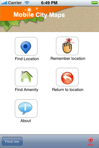
Port-au-Prince Haiti Street Map -do you feel online Google Maps is too slow showing you the map? Do you want an easy way to mark and remember where you are? Do you need a list of streets where you are? You don’t want to carry around a big unwieldy paper map? Tired of having the paper map blown to pieces by the wind every time you try to figure out where you are and where you need to go?
The mobile streetmaps are for you! All the map data is loaded on your iPhone before you leave your home, so can you be on the streets, offline, and still know everything about the area you are in, and locate yourself or any street in the city. You don’t need any network connection at all once the application is installed on your iPhone – no WiFi, no 3G, no GPRS!
This is a complete street level map for your iPhone. The entire map is stored on your iPhone, so it works where you have no access to the Internet - it works where Google Maps is inaccessible. This prevents expensive data roaming charges by loading all the map data to your iPhone before you leave home. You can turn off all network functions and still be able to find your way around. Lets you find all streets, and many useful locations such as ATM's, parkings, museums, and many others. Remembers where you've been so you can find that parking spot where you left your rental car, or that great restaurant. Allows you to mark interesting locations to visit in advance. To make sure your iPhone doesn't use any expensive data on your trip, go to Settings, then General, tap on Network, and slide the Data Roaming to "off". Note: GPS functions work on the iPhone only.
Map data (c) OpenStreetMap and contributors, CC-BY-SA.
What's New in This Release:
· iOS 4 compatibility
Like it? Share with your friends!
If you got an error while installing Themes, Software or Games, please, read FAQ.
Supported operating systems:
Apple iOS 10.x (iPad), Apple iOS 10.x (iPhone), Apple iOS 11.x (iPad), Apple iOS 12.x (iPad), Apple iOS 12.x (iPhone), Apple iOS 4.0.x (iPhone), Apple iOS 4.0.x (iPod Touch), Apple iOS 4.2.x (iPad), Apple iOS 4.2.x (iPhone), Apple iOS 4.2.x (iPod Touch), Apple iOS 4.3.x (iPad), Apple iOS 4.3.x (iPhone), Apple iOS 4.3.x (iPod Touch), Apple iOS 5.0 (iPad), Apple iOS 5.0 (iPhone), Apple iOS 5.0 (iPod Touch), Apple iOS 6.0 (iPad), Apple iOS 6.0 (iPhone), Apple iOS 6.0 (iPod Touch), Apple iOS 7.0 (iPad), Apple iOS 7.0 (iPhone), Apple iOS 7.0 (iPod Touch), Apple iOS 8.x (iPad), Apple iOS 8.x (iPhone), Apple iOS 8.x (iPod Touch), Apple iOS 9.x (iPad), Apple iOS 9.x (iPhone), Apple iOS 9.x (iPod Touch), Apple iPhone OS 3.2.x (iPad)
Similar Software:
Agate Fossil Beds National Monument - GPS Map Navigator Agate Fossil Beds National Monument - GPS Map Navigator - Continues in the tradition of offering depth of information and functionality across expected places all over the world, exploring the map you get maximum details obtaining detailed information of each object on the map
Barcelona Metro 10 for iPad Barcelona Metro 10 - This Zuti application contains a visually unique map of the Barcelona transport system and a superb animated journey planner to help you get around the TMB (Transports Metropolitan de Barcelona), FGC (Ferrocarrils de la Generalitat de Catalunya) Metro and Tram services
San Jose Map and Walking Tours San Jose Map and Walking Tours - This Lite version of the walking tours application comes with a detailed and fully functional city map to assist you explore the city and locate sights. City map functions in this app include: street name and business (restaurants, cafes, etc
Jasmund National Park - GPS Map Navigator Jasmund National Park - flytoMap provides complete, quick and easy to use map applications for navigation for iPhone. Continues in the tradition of offering depth of information and functionality across expected places all over the world, exploring the map you get maximum details obtaining detailed information of every object on the map
Beijing Street Map Beijing Street Map. Lets you find all streets, and many useful locations such as ATM's, parkings, museums, and many others. Remembers where you've been so you can find that parking spot where you left your rental car
Berchtesgaden National Park - GPS Map Navigator Berchtesgaden National Park - GPS Map Navigator - FlytoMap provides complete, quick and easy to use map applications for navigation for iPhone. Continues in the tradition of offering depth of information and functionality across expected places all over the world, exploring the map you get maximum details obtaining detailed information of every object on the map
Vietnam Map Vietnam Map - This application enables you to use maps offline without internet connection. This includes maps street names detail. This will give peace of mind when traveling aboard knowing you will not be charged with roaming fee. So if you live or travel in that city, it will help you much in your life
Groningen (Netherland) Map Offline Groningen (Netherland) Map Offline - This will be perfect when you are traveling and you don't have internet connection. This Offline Maps is not a replacement of Google Maps. It is used when you don't have internet connection and want to use maps
Gogo Navigator USA & CAN Gogo Navigator USA & CAN is a real-time, turn-by-turn 3D navigation app. It features real-3D, Text-To-Speech voice guidance, Advanced Lane Guidance, real Signpost display, millions of onboard POIs and much more
Maps+ Maps+ - Browse Google's maps, find out where you are, search the map, get directions with route alternatives, use location-based alarms, record and edit GPS tracks, scan the map for tweets and export & import your bookmarks with Maps+, the map application with a plus for iPhone, iPod touch and iPad
Providence Street Map Providence Street Map - Lets you find all streets, and many useful locations such as ATM's, parkings, museums, and many others. Remembers where you've been so you can find that parking spot where you left your rental car
Nashville Street Map Nashville Street Map - Lets you find all streets, and many useful locations such as ATM's, parkings, museums, and many others. Remembers where you've been so you can find that parking spot where you left your rental car
El Paso Street Map El Paso Street Map - Lets you find all streets, and many useful locations such as ATM's, parkings, museums, and many others. Remembers where you've been so you can find that parking spot where you left your rental car
Turku Turku - Lets you find all streets, and many useful locations such as ATM's, parkings, museums, and many others. Remembers where you've been so you can find that parking spot where you left your rental car. To make sure your phone doesn't use any expensive data on your trip, go to Settings, then General, tap on Network, and slide the Data Roaming to "off"


 Map Offline")


