Platforms: iPhone, iPad, iPod Touch, Apple iPhone OS
Categories: Travel & Navigation
Upload date: 21 Jul 12
Developer: Flytomap
License: Commercial
Price: 2.99 $
Downloads: 186
Crete (Greece) - GPS Map Navigator - FlytoMap provides complete, quick and easy to use map applications for navigation for iPhone. Continues in the tradition of offering depth of information and functionality across expected places all over the world, exploring the map you get maximum details obtaining detailed information of every object on the map.
FlytoMap processes different types of maps for navigation for different categories:
WATER MAPS (Marine):
Water map navigator is the new ‘Marine Navigator for iPhone’ contains embedded Electronic Nautical Charts (ENC) from NOAA compressed to a large coverage. You can now download the application and transform your iPhone in a chart plotter with best NOAA, ENC S57 cartography; which includes Anchoring areas, Fishing areas, restriction areas, obstructions, rocks, Buoys, Beacons, Lights, Depth contours with Values display on map, Spot Soundings and more. The only marine app available in the market with such huge information. Every effort is made to be as accurate as possible when presenting information for every destination.
PARK MAPS:
Park map applications are extremely advanced contains embedded electronic charts with all information collected from the National Park Service and local sources. The maps contain all multiple trails (Hiking, biking, Stairway trails, Bicycle trails, Equestrian trails etc.,) and Point of interests (POI) like Campgrounds, Eating places, Ranger Stations, Picnic areas, Boat/Canoe launching, Parking areas etc., which are provided depending on the relevant park areas they exist.
LAKE MAPS:
We offer high quality lake maps with detailed information and important features compressed to assure the larger coverage in USA region. Lake maps contain most important DNR lakes with detailed ‘Depth Contours, Boat Ramps, Fishing spots etc. Also includes Trails, Roads and Railways information.
TRAVEL MAPS:
These Maps treat you mostly with information of both Marine and terrain correspondingly. These are the most preferable Maps to travel especially for fascinating recreational voyages, map focus the best Beach spots along the Coast line, Major ports, Sailing, Fishing, Picnic areas, Parks, Hiking, Biking, Clubs, restaurants, Famous Hotels, Museums, Shopping areas, and much more.
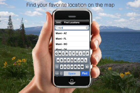
· Use Latitudes and Longitudes to go to your favorite places
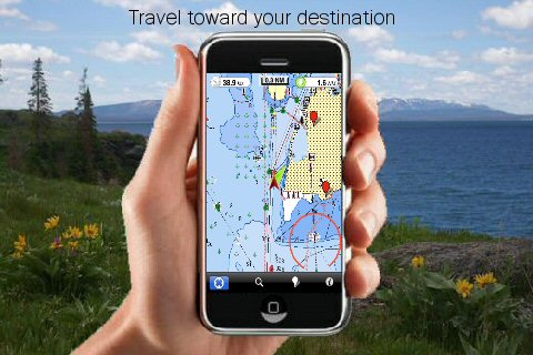
· Insert the target/destination 'Waypoint' and see in real time your speed, distance and direction to destination
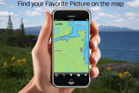
· Insert Unlimited Markers near favorite places on the map
· Search your Favorite points directly
· Zoom, Rotate and Pan fast just by a finger touch
· Navigate and see your GPS position on the map
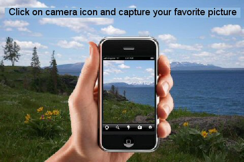
· Geo-Tagged photo management
· Set On/Off Elevation Contours if you feel data is cluttering
What's New in This Release:
· Display of FlytoMap Overlay
· Improved Track Collection when Walking
· Solved a Configuration Problem when Outdoor layer is active.
What's New in 2.5.1:
· Minor bug fixed
· Retina display management
Like it? Share with your friends!
If you got an error while installing Themes, Software or Games, please, read FAQ.
Supported operating systems:
Apple iOS 10.x (iPad), Apple iOS 10.x (iPhone), Apple iOS 11.x (iPad), Apple iOS 12.x (iPad), Apple iOS 12.x (iPhone), Apple iOS 4.2.x (iPad), Apple iOS 4.2.x (iPhone), Apple iOS 4.2.x (iPod Touch), Apple iOS 4.3.x (iPad), Apple iOS 4.3.x (iPhone), Apple iOS 4.3.x (iPod Touch), Apple iOS 5.0 (iPad), Apple iOS 5.0 (iPhone), Apple iOS 5.0 (iPod Touch), Apple iOS 6.0 (iPad), Apple iOS 6.0 (iPhone), Apple iOS 6.0 (iPod Touch), Apple iOS 7.0 (iPad), Apple iOS 7.0 (iPhone), Apple iOS 7.0 (iPod Touch), Apple iOS 8.x (iPad), Apple iOS 8.x (iPhone), Apple iOS 8.x (iPod Touch), Apple iOS 9.x (iPad), Apple iOS 9.x (iPhone), Apple iOS 9.x (iPod Touch)
Angelina National Forest - Standard Angelina National Forest - Standard - Continues in the tradition of offering depth of information and functionality across expected places all over the world, exploring the map you get maximum details obtaining detailed information of each object on the map
Marine: Gargano - GPS Map Navigator Marine: Gargano - GPS Map Navigator - Flytomap offers revolutionary Marine applications for iPhone, iPod Touch & iPad!!!
Go boating in the wonderful Gargano waters - discovering the bays of Gargano is an unforgettable experience.
Gorgano Marine Map contains embedded Electronic Nautical charts compressed to a large coverage
Istanbul Map and Walking Tours Istanbul Map and Walking Tours - This Lite version of the walking tours application comes with a detailed and fully functional city map to assist you explore the city and locate sights. City map functions in this app include: street name and business (restaurants, cafes, etc
Cambridge(Massachusetts) World Travel Cambridge(Massachusetts) World Travel - map with locate me function makes you free to move.
Background reading always accompanies you on your trip
Hamilton Maps Offline Hamilton Maps Offline - This will be perfect when you are traveling and you don't have internet connection. This Offline Maps is not a replacement of Google Maps. It is used when you don't have internet connection and want to use maps
Lakes: Massachusetts Lakes: Massachusetts - FlytoMap provides complete, quick and easy to use map applications for navigation for iPhone. Continues in the tradition of offering depth of information and functionality across expected places all over the world, exploring the map you get maximum details obtaining detailed information of every object on the map
Leeds Maps Offline Leeds Maps Offline - This will be perfect when you are traveling and you don't have internet connection. This Offline Maps is not a replacement of Google Maps. It is used when you don't have internet connection and want to use maps
Bratislava Map Offline Bratislava Map Offline - This will be perfect when you are traveling and you don't have internet connection. This Offline Maps is not a replacement of Google Maps. It is used when you don't have internet connection and want to use maps
Other Software by developer «Flytomap»:
Theodore Roosevelt National Park - GPS Map Navigator Theodore Roosevelt National Park - GPS Map Navigator - Continues in the tradition of offering depth of information and functionality across expected places all over the world, exploring the map you get maximum details obtaining detailed information of each object on the map
Asinara National Park - GPS Map Navigator Asinara National Park - GPS Map Navigator - FlytoMap provides complete, quick and easy to use map applications for navigation for iPhone. Continues in the tradition of offering depth of information and functionality across expected places all over the world, exploring the map you get maximum details obtaining detailed information of every object on the map
Phuket Island HD - GPS Map Navigator Phuket Island HD - GPS Map Navigator - FlytoMap provides complete, quick and easy to use map applications for navigation for iPad. Continues in the tradition of offering depth of information and functionality across expected places all over the world, exploring the map you get maximum details obtaining detailed information of every object on the map
Marine: Alaska South West - GPS Map Navigator Marine: Alaska South West - GPS Map Navigator - FlytoMap provides complete, quick and easy to use map applications for navigation for iPhone. Continues in the tradition of offering depth of information and functionality across expected places all over the world, exploring the map you get maximum details obtaining detailed information of every object on the map
Lake Winnebago - Fishing Lake Winnebago - Fishing - Lake Winnebago is the largest, natural inland lake in the United States having 137,708 acres coverage. It is very shallow with an average depth of 15.5 - 21 feet.
For fishing lovers Lake Winnebago is one of the more heavily fished lakes in Wisconsin
Seychelles HD - GPS Map Navigator Seychelles HD - GPS Map Navigator - FlytoMap provides complete, quick and easy to use map applications for navigation for iPad. Continues in the tradition of offering depth of information and functionality across expected places all over the world, exploring the map you get maximum details obtaining detailed information of every object on the map
Egadi Islands - GPS Map Navigator Egadi Islands - GPS Map Navigator - Continues in the tradition of offering depth of information and functionality across expected places all over the world, exploring the map you get maximum details obtaining detailed information of each object on the map
Cabaneros National Park - GPS Map Navigator Cabaneros National Park - GPS Map Navigator - FlytoMap provides complete, quick and easy to use map applications for navigation for iPhone. Continues in the tradition of offering depth of information and functionality across expected places all over the world, exploring the map you get maximum details obtaining detailed information of every object on the map
Nantahala National Forest Nantahala National Forest - Continues in the tradition of offering depth of information and functionality across expected places all over the world, exploring the map you get maximum details obtaining detailed information of each object on the map
Marine: Alaska South East - GPS Map Navigator Marine: Alaska South East - GPS Map Navigator - FlytoMap provides complete, quick and easy to use map applications for navigation for iPhone. Continues in the tradition of offering depth of information and functionality across expected places all over the world, exploring the map you get maximum details obtaining detailed information of every object on the map

 - GPS Map Navigator")
 - GPS Map Navigator")


 World Travel")


