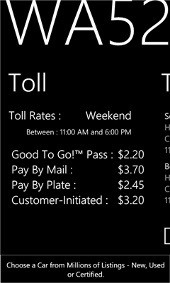
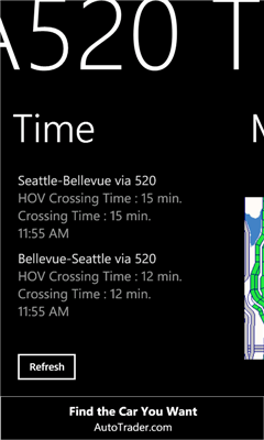
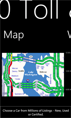
Washington SR 520 Toll & Traffic - Electronic tolling on SR 520 will begin this spring. Be ready by checking how much it will cost you to cross SR 520. Application takes in account US Holidays and provides additional information, such as current crossing time for both directions, and traffic map of the bridges.
Like it? Share with your friends!
If you got an error while installing Themes, Software or Games, please, read FAQ.
Supported operating systems:
Windows 10 Mobile, Windows Phone 7, Windows Phone 8
Similar Software:
WorldMaps Developed by Salman Shakeel
This application provides you total solution to navigation it is combinations of multiple maps at one place
Bochum Total Diese Anwendung ist eine ubersicht uber alle Acts bei Bochum Total und das Bermuda-Dreieck
FidMe FidMe - Toutes vos cartes de fidélité réunies sur votre mobile !
FidMe, le portecarte mobile pour vos cartes de fidélité !
Innovante et simple à utiliser FidMe : enregistrez vos cartes de fidélité en quelques secondes
Map Services This application let the user to view maps, trace routes between two places, find a place, query for the weather in the current map position
Find My Car Find My Car Have you every parked your car and then went about your day, only to realize at the end of the day that you don't recall where you parked it? Then "Find My Car" is for you.
What's New in This Release:
· Updated to support copy and paste functionality and update Bing maps
GMapPro GMapPro - Features:
1. Use Google Maps which is the most complete mapping solution available in the world
2. Download the maps of desired area, and use them while you are offline
3. Provide a list of downloads so you can delete them in future (if you don't wish to keep them anymore)
4. Use the phones internal GPS, to find you on the map
5. Markers:
5
Bing Get Me There Bing Get Me There - Bing Get Me There is a London travel app that gets you from where you are right now to wherever you want to be. True door-to-door directions using Bing maps and live tube updates to ensure you get the best route for you
Free World Explorer Free World Explorer - So, you think you are good at geography? Let's see how good you are :)
Pan the map to fly the plane to the destination place and click on land button when you find the green airport symbol. You need to be connected to internet for this. Difficulty mode to challenge you with a lot more countries
Other Software by developer «Peter Dotsenko»:
not found
Comments on Washington SR 520 Toll & Traffic:
Comments not found
If you noted an error or download link is broken, please, report it via this page or use comments.
Washington SR 520 Toll & Traffic is compatible with your device Alcatel One Touch Idol 4S with Windows 10 6071w