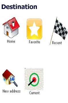
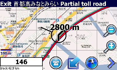
Mobile Traveler enables you when you are traveling abroad (e.g. Japan) to find your way around there. It uses Google to find routes and enables pre-fetching parts of Google maps at home or any where you have WiFi or cheap data rates of your mobile telephone provider. Besides this it is especially useful when you are visiting Japan. Traveling in Japan with the public transport is very safe and a fast way to move around. MobileTraveler contains almost all Japans Honsu area train lines and all shinkansen tracks. And best of all it's freeware
What's New in This Release
· Updated because of bug that slowly fills main memory when downloading tiles is on. This due to the fact that they where stored in the main memory instead of the storage card.
Like it? Share with your friends!
If you got an error while installing Themes, Software or Games, please, read FAQ.
Supported operating systems:
Windows Mobile 5.0, Windows Mobile 5.0 Smartphone, Windows Mobile 6 Classic, Windows Mobile 6 Professional, Windows Mobile 6 Standard, Windows Mobile 6.1 Classic, Windows Mobile 6.1 Professional, Windows Mobile 6.1 Standard, Windows Mobile 6.5 Professional, Windows Mobile 6.5 Standard
Similar Software:
FON Access Points for Luxembourg FON Access Points for Luxembourg - FON offers you a new Points of Interest service (POIs). This allows you to download FONspots directly to your navigation device.
What does that mean? You can download a Points of Interest file directly to your navigation device
PictureGPS PictureGPS allows you to tag pictures from your PocketPC camera in real time with a GPS stamp and view the distance of each picture via your current GPS. You can use the ruler to view the distance of each picture and also view the GPS stats for each picture with a Google.com map. The map service is provided by Google
TravelGPSer TravelGPSer - TravelGPSer uses the GPS on your PocketPC to graphically view your GPS movement. You can adjust the slider for to view larger distances on the map. This uses "The Vincenty inverse formula for ellipsoids" (accuracy to within 0.5mm, or 0.000015").
This program requires that you have both the 'BeanDLL
PoliceGPSer PoliceGPSer - PoliceGPSer converts the PocketPC into a GPS locator and reporter device. Select the update interval and the program will send the GPS location of the device to a FTP server at the interval. You can view the GPS of all GPS devices with the PocketPC PoliceGPSes.
This program requires that you have both the 'BeanDLL
GPSmeter Do you still use your GPS device for navigating only?
Turn your Pocket PC into a high precision metering machine using your GPS receiver! With MASPware GPSmeter you can measure short and long distances (beeline or routelength), altitude differences, timespans, average values and min-max-values using an internal or external GPS receiver
SIGLOG SIGLOG - A Windows Mobile application that logs latitude, longitude, signal strength, mobile country code, mobile network code, location area code, CellID.
Written in Win32 C++ it's lean, mean, rather basic, but it does the job. It requires a phone with GPS, as it calls the Microsoft intermediate GPS driver
NoniGPSPlot NoniGPSPlot allows you to locate your position in relation to other GPS points and to see the journey you have made.
It may be used to find your starting place in a port after sailing, or the place where you start a walking or biking excursion, or even your car in a parking. Any place long as you know its GPS coordinates.
It stores the whole journey too
TravelGoogling TravelGoogling allows you to use the GPS on your PocketPC to find 5,451 local stores and services in sorted via distance. Tap the button to start the GPS and when you get the lock tap the button to view the business directory. Tap on a business category to view local business listings. The GPS street information is from GeoNames
CellGPSing CellGPSing uses the cellular signal on your device to instantly find your approximate GPS and display on a Google.com map. Tap the button while your phone is on and the program will send your cellular tower information to OpencCellID.org. The program will then display the approximate GPS. This service is provided by OpenCellID
MapSpeedometers MapSpeedometers - MapSpeedometers uses the GPS on your PocketPC to measure your speed in and says it in a computerized voice at an interval that you select. You can select Miles/Km/h and Nautical Miles and the program will repeat the speed-reading at the selected interval.
This program requires that you have both the 'BeanDLL
Other Software by developer «MobileTraveler»:
not found
Comments on MobileTraveler:
nestor freitas:
por enquanto nada a comentar
Date: 26 May 10
If you noted an error or download link is broken, please, report it via this page or use comments.
MobileTraveler is compatible with your device Airo A25