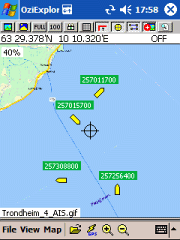
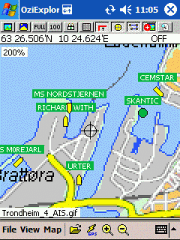
AIS2OZI - AIS2OZI tracks ship positions. It is a logger/decoder/plotter for PocketPC.
Ship positions are plotted directly in OziExplorer Download AIS2OZI (Make backup of Shiplist.txt when reinstalling.)
Decodes AIVDM sentences of types 1, 2, 3 and 5, i.e. position reports for class A shipborne equipment plus vessel information.
Like it? Share with your friends!
If you got an error while installing Themes, Software or Games, please, read FAQ.
Supported operating systems:
Windows Mobile 5.0, Windows Mobile 6 Classic, Windows Mobile 6 Professional, Windows Mobile 6.1 Classic, Windows Mobile 6.1 Professional, Windows Mobile 6.5 Professional
Similar Software:
CyberTracker 3 CyberTracker 3 - Capture data in the field using our unique icon-based user interface and a GPS for georeferencing. Analysis of the results can be done either in CyberTracker or exported to a third party program. Requires PocketPC 2002/2003/WM5+ or Palm 3 and higher
FileGPSed FileGPSed - FileGPSed allows browse and view GPS tagged Excel, Word, Note, Voice, Text and Picture/Video files. You can browse the folders of the PocketPC for GPS tagged files and view them via GPS distance from your current location. Tap on the file to open it in the associated application.
This program requires that you have both the 'BeanDLL
chtiGPS chtiGPS is intended to the sportsmen and to hikers, for their training (bicycle, rollers, ski...), but also to locate itself by knowing the distance and the direction from the closest cities. Geolocalization finally makes it possible to reassure its close relations at the time of great exits..
FON Access Points for Mayotte FON Access Points for Mayotte - FON offers you a new Points of Interest service (POIs). This allows you to download FONspots directly to your navigation device.
What does that mean? You can download a Points of Interest file directly to your navigation device
Woodpecker GeoScout GeoScout is designed to be the only software you need to go geocaching. You can download/import, view and manage all caches of interest. With a connection to a suitable GPS, GeoScout can also guide you to the cache waypoint(s).
GeoScout requires individual gpx files for each cache, however don''t worry if you don''t have these
FON Access Points for Singapore FON Access Points for Singapore - FON offers you a new Points of Interest service (POIs). This allows you to download FONspots directly to your navigation device.
What does that mean? You can download a Points of Interest file directly to your navigation device
GPSSateliter GPSSateliter displays the GPS satellite listings and strength as a graph. When you tap the 'Start GPS' button the program will look for GPS satellites and graphically display the decibel of each. The more bars the better your GPS coverage
FON Access Points for Chile FON Access Points for Chile - FON offers you a new Points of Interest service (POIs). This allows you to download FONspots directly to your navigation device.
What does that mean? You can download a Points of Interest file directly to your navigation device
Other Software by developer «Frank Dahlslett»:
not found
Comments on AIS2OZI:
Comments not found
If you noted an error or download link is broken, please, report it via this page or use comments.
AIS2OZI is compatible with your device Airis T480 / T480E


")

