Rough Guides Map Barcelona... These guides are a series of fantastic interactive maps.
Produced in conjunction with the premier travel publisher Rough Guides.
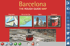
Discover and explore Barcelona using full colour interactive linked maps, in this simple to use PDA version of The Rough Guides Barcelona.
Find all the top tourist spots and key attractions with ease, information on the city and its sights can be quickly displayed with links to photographs and map locations. All in a superb easy to use interface.
If you''re travelling to Barcelona, be sure you don''t leave home without this guide on your PDA.
The Rough Guide city maps includes:
Fully scrollable and interactive maps of the city.
Tap any location to display information and available links.
Intuitive navigation bar meaning you are never more than one click away from the information you require.
Map links allow you to directly link to other maps, photographs, or detailed views.
Categorised Find feature allowing you to quickly find any street, place of interest or station.
Categorised Information feature providing a wealth of information on the city, places of interest, etc.
1-Click Home feature, keeping the Home map always at hand.
Zoom function on all maps.
Special Offer Only $20.00
Hi Res & landscape displays supported.
Like it? Share with your friends!
If you got an error while installing Themes, Software or Games, please, read FAQ.
Supported operating systems:
Pocket PC 2002, Windows Mobile 2003, Windows Mobile 5.0, Windows Mobile 6 Classic, Windows Mobile 6 Professional, Windows Mobile 6.1 Classic, Windows Mobile 6.1 Professional, Windows Mobile 6.5 Professional
Similar Software:
MyTravelr Mytravelr is a set of tools designed to help on-the-go mobile users maximize their productivity and reduce the stress of trave.
1.0F3 version:
- Fixed bug: some cities DST issue.
- Fixed bug: Weather update from forecast screen.
- Added: Option for disabling Internet Network confirmation.
1.0F2 version:
- Added: Edit cities feature (Add/Update/Delete)
MapsGo MapsGo - Simple GIS for Desktop and Pocket PC with export to MapMap for Palm
Travel Ireland - illustrated guide and maps. Incl: Dublin, Cork, Galway and more. FREE General Info Travel Ireland - illustrated guide and maps. Incl: Dublin, Cork, Galway and more. FREE General Info - An illustrated guide and maps. Indulge Yourself with a personal tour guide on Your PDA. FREE General Information chapter and a map in the trial version.
Features
Fully illustrated.
Historical overviews.
Interesting facts.
City Attractions
Map of Zimbabwe Map of Zimbabwe - A map of Zimbabwe. Good for intercity travels with SmartMap.
Layers include:
Towns
Settlements
Airports
Roads
Railroads
Rivers
Inland water
Administrative borders
International borders
Trees
Map scale is 1:1 million.
Good for use with any version of SmartMap. SmartMap can be purchased here
Travel Mammoth Cave National Park - illustrated travel guide and maps- Travel Mammoth Cave National Park is a comprehensive travel guide illustrated with maps and photographs. Indulge Yourself with a personal tour guide on Your PDA. FREE General Information chapter and a map in the trial version.
Features
Fully illustrated.
Geology, Flora, Fauna and more.
Interesting facts.
Area Maps and Trail Maps
TerraTrack Recorder 7 Route guidance in 3D view, makes navigation processes very simple and intuitive
Map of Philippines Map of Philippines - A map of Philippines. Good for intercity travels with SmartMap.
Layers include:
Towns
Settlements
Airports
Roads
Railroads
Rivers
Inland water
Administrative borders
International borders
Trees
Map scale is 1:1 million.
Good for use with any version of SmartMap
Map of Shanghai (Chinese) / China for City Advisor Map of Shanghai (Chinese) / China for City Advisor - A Chinese version of Shanghai / China Metro map with all updated 10 metro lines. Find station with first letter of pinyin, ex: the keyword of Shanghai Railway Station is hcz.
1. Download the map (zip file)
2. Extract the files in /CityAdvisor/maps
3. Open CityAdvisor -> Maps icon -> Menu -> Refresh
4
Other Software by developer «Visual IT»:
Tube Melbourne (Series 60) Tube Melbourne (Series 60) - Our highly acclaimed Tube application that guides you around the metro and rail system of Melbourne is now available for your Series 60 Symbian powered phone. An essential addition to your phone for locals and tourists alike.
· A detailed clear colour map of the Melbourne metro & rail system fully scrollable
Tube 2 Amsterdam (Palm OS) Tube 2 Amsterdam (Palm OS) - This map package for Tube 2 consists of a fully scrollable detailed map of the Amsterdam tram & metro system.
Plan journeys on this system, list details of the quickest routes and see a superb animated display of your journey tracking around the system map
London Mini A-Z for iPad London Mini A-Z for iPad - This clear and colourful high quality map is a digital rendition of the famous "London A-Z Mini Atlas" and covers an area from West Hendon in the North West to Grove Park in the South East. Add this application to you iPad and you will have instant access to all 352 pages of the London Mini A-Z printed map
London Visitors A-Z London Visitors A-Z - The London Visitors Map of central London is designed especially for the tourist. The principal feature of the mapping is the highlighting of places of interest, buildings open to the public, theatres, cinemas, selected shops and stores, main shopping streets, main line and underground railway stations and other locations of interest to the visitor
Great Britain Rail by Zuti Great Britain Rail by Zuti - The new Great Britain Rail map makes it easy to travel in and around the country using the rail services. This application contains a geographically accurate map of the whole of Great Britain allowing you to easily view the route of any journey
Tube 2 Brussels (UIQ) Tube 2 Brussels (UIQ) - This map package for Tube 2 consists of a fully scrollable detailed map of the Brussels tram, metro & bus system.
Plan journeys on these systems, list details of the quickest routes and see a superb animated display of your journey tracking around the system map
Tube Moscow (Series 60) Tube Moscow (Series 60) - Our highly acclaimed Tube application that guides you around the complex metro system of Moscow is now available for your Series 60 Symbian powered phone. An essential addition to your phone for locals and tourists alike.
· A detailed clear colour map of the Moscow metro system fully scrollable.
· Quick find station utility
Tube 2 Boston Pro (UIQ3) Tube 2 Boston Pro (UIQ3) - This map package for Tube 2 consists of a fully scrollable detailed map of the Boston metro & commuter rail system and linked street maps of central Boston.
Plan journeys on the metro system, list details of the quickest routes and see a superb animated display of your journey tracking around the system map
Tube Chicago (Palm OS) Tube Chicago (Palm OS) - subway mapAn award winning and highly acclaimed Palm OS application that guides you around the complex subway system of Chicago. An essential addition to your Palm device for locals and tourists alike.
Tube's features include:
A detailed clear colour (or grey scale) map of the transport system fully scrollable.
Quick find station utility
Tube 2 Washington (Palm OS) Tube 2 Washington (Palm OS) - This map package for Tube 2 consists of a fully scrollable detailed map of the Washington D.C. metro system.
Plan journeys on this system, list details of the quickest routes and see a superb animated display of your journey tracking around the system map


 Hi Res & landscape displays supported.


![USA-WI [Wisconsin] Map for EagleEye PDA Tracking System](https://static.mobyware.org/data/images/def_program_reduced.png "USA-WI [Wisconsin] Map for EagleEye PDA Tracking System")


 / China for City Advisor")
")
")


")
")
")
")