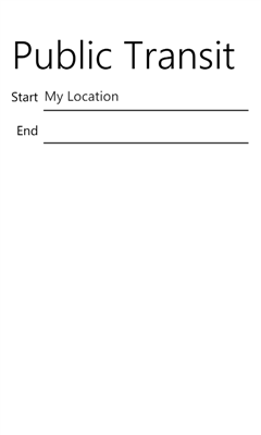
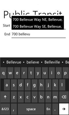
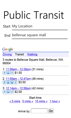
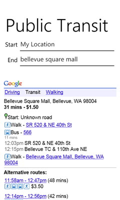
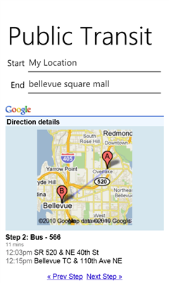
Public Transit for Windows Phone helps you find your way around using public transit facilities. No need to enter your current address, just use "My Location" and let GPS + Google Transit get you to your endpoint. If you prefer not to use your location, simply enter your start and end addresses manually.
V1.4 Proper support for regional settings
Please send feeback to wpdev@hotmail.com
Like it? Share with your friends!
If you got an error while installing Themes, Software or Games, please, read FAQ.
Supported operating systems:
Windows 10 Mobile, Windows Phone 7, Windows Phone 8
Similar Software:
Sunnyvale Find information about the City of Sunnyvale. You can find Sunnyvale Hospitals, Hotels, Parks, Railway stations, Universities and Maps.Once installed this App can provide you useful information
Colombo Colombo - Find information about the City of Colombo. You can find Colombo Hospitals, Hotels, Church, Parks, Railway Stations, Police, Universities and Maps.Once installed this App can provide you useful information stored locally on your device
Seattle Traffic Seattle Traffic is the quickest way to view Seattle-area traffic on your Windows Phone!
It is designed to be fast, simple, and easy-to-use. (Even while driving, but don't do that!)
Seattle Traffic shows the main Washington State Department of Transportation traffic map, perfectly formatted to fit your phone
Travelocity Travelocity - Travel info & tools while you're on the go
Wanderlust Wanderlust - Wanderlust is a left-field and totally experimental boutique hotel set to draw madcap voyagers and curious travellers to its doorstep
Paris GPS Metro Paris GPS Metro - Find information about the Metro Railway system in Paris. You can find Paris Metro map, Lines, Stations and City info with ease. Once installed this App can provide you useful information stored locally on your phone
DCMetro DCMetro - The complete app for the Washington DC Metro! Find the nearest station, check on train arrival times, get directions to a station and more.
Also check up on the most recent disruptions, tweets, and news items published by the metro authority!
Not affiliated with WMATA, all data is gathered from feeds available through WMATA
GBS "GBS - GPS for Bucharest Subway" is a navigation system for the Bucharest subway's travelers that works both for travel at the surface and underground. From now on, you will not be late for
Boston Maps Boston Maps - This app contains offline public (no data connection necessary after first download) transportation maps for the Boston area.
Includes
subway
commuter rail
commuter boat
water taxi
Boston detail maps
MBTA system maps
Can be used in portrait or landscape view
Other Software by developer «WPDev»:
not found
Comments on Public Transit:
Comments not found
If you noted an error or download link is broken, please, report it via this page or use comments.
Public Transit is compatible with your device Acer Liquid M220 Plus Dual SIM