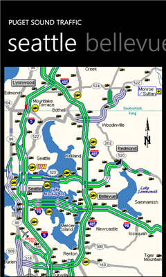
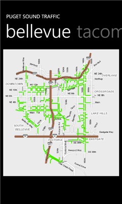
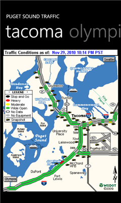
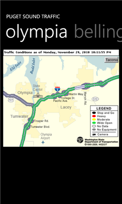
Puget Sound Traffic is a simple and quick way to view traffic conditions in the Puget Sound area.
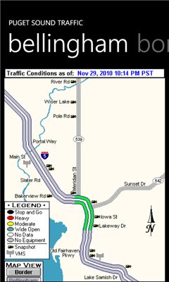
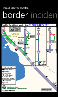
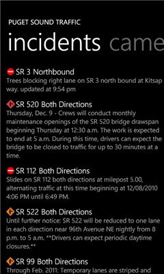
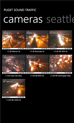
Maps are fetched from the Washington State Department of Transportation as well as other sites for Seattle, Bellevue, Tacoma, Olympia, Bellingham and the US/Canada border. Recent incidents from the WSDOT area also displayed.
Maps are not interactive. The maps are just the most recent images from the WSDOT.
Gently shake the phone to refresh the current view.
------
Version 1.2 makes adding cameras a bit easier. It also contains some bug fixes and performance enhancements.
Version 1.1 adds support for pinning your favorite traffic cameras to the cameras page. This version also adds a trial version which is ad supported. The paid version removes the ads.
Please visit http://www.straypixel.com for comments/suggestions.
Like it? Share with your friends!
If you got an error while installing Themes, Software or Games, please, read FAQ.
Supported operating systems:
Windows 10 Mobile, Windows Phone 7, Windows Phone 8
Similar Software:
MapStalt Mini MapStalt Mini is an application that is meant to bring the map to completeness. In the case of the open street map, many details are missing, and MapStalt puts to power to complete the map into the hands of the mobile user. With MapStalt, a user can add something as simple as a building address and latitude/longitude or complex details such as business hours of operation
SaraMap SaraMap is a Free Map Application that integrates with Google Map,Microsoft Bing Map and OpenStreetMap.it supports GPS Tracking either.
Main Features:
-Map Navigation with different layers support.
-Using Multi Scale Image control as map viewer core with Multi touch pan/zoom behavior.
-Switch easily between Google Map,Bing Map and OpenStreetMap
-GPS Tracking
ver 1
Map Compare Map Compare - Map Compare allows you to compare 12 different maps from Bing, Google, Yahoo and Open Street Maps side by side on a single screen
Googlemaps Googlemaps - Enjoy Almost all features of Google Maps on your WindowsPhone7
Enjoy The Water-overlay mode, Physical mode, Hybrid mode, Satellite View, Street-View.
You can zoom in and zoom out without any Hindrance
Mr.Map Mr.Map help users to find any place on the world using world map
Wenak Mobisoft Wenak lets you share your location with your friends, family members, co-workers and loved ones by making it easy to tell them where you are and see each other on the map.
Wenak lets you share your location in the background, even when the app is closed
Canada Topography Canada Topography - provides topographic information for the entire country of Canada. The maps provide details such as altitude, railways and numerous other layers. Using the GPS you can center on your current location and even zoom to specific areas of the country.
All maps are provided by Geocratis Canada (http://www.geogratis.gc.ca/geogratis/en/service/toporama
GMap Pro GMap Pro - Ultimate Google Maps for Windows Phone 7
In new version we have added China region detection and offset auto correction. We have also improved navigation by adding auto rerouting and current step highlighting.
We appreciate your feedback. Help us make tool you’d like
Transit Maps USA Free Transit Maps USA Free - The only Transit Maps app of its kind. You can select the city you want to see the transit maps for and zoom in to view the map in detail on the full screen. You can easily zoom-in, pan, and zoom-out using one hand only. You can now plan your trip from anywhere, any time - no Internet/data connection required
Other Software by developer «Eric Davison»:
Leaderboard Leaderboard - Wondering who's leading at this week's tour stop? Fire up Leaderboard to get a quick view of the top 20 or so players. Tap the leaderboard to get a full, more detailed view.
Gently shake the phone to refresh.
http://www.straypixel