Interstate Road Conditions - While I was driving down the road, I found that there were no applications that allowed me to quickly get information about the road conditions of the interstate that I was travelling. Although, sites like Weather.com provide maps of road conditions, these are hard to quickly navigate to via the browser.
What I wanted was a simple app that gave me a way to find out quickly about the road conditions in my region. In addition, the application needed to allow me quickly browse to the Weather.com website so that I could get in-depth information about the conditions.
Out of these requirements was born "Interstate Road Conditions" (I.R.C) Windows Phone 7 application.
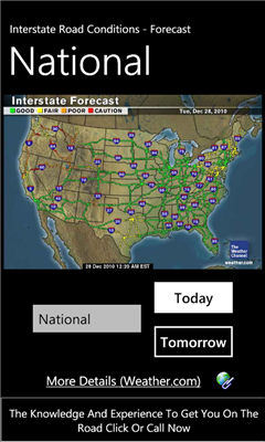
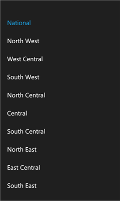
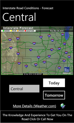
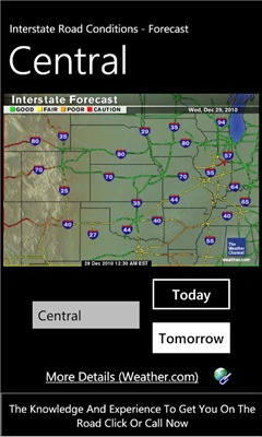
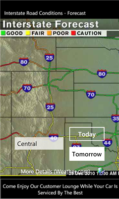
Interstate road conditions provide a quick way to get an overview of road conditions across the United States. In addition, you can zoom in to a particular region of the U.S (north-west, west-central, south-west, north-central, central, south-central, north-east, east-central, south-east).
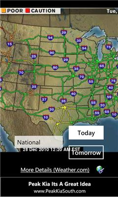
I.R.C also allows you to zoom into the map (via pinching) and dragging to a spot of interest. Double tapping the map resets it (or zooms into it).
The toggle button allows you to change between a map for today and a map for tomorrow.
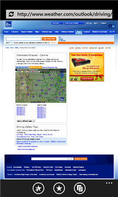
Finally, the More Info, link takes you to the Weather.com website page, where you can get in-depth information about forecasts, as well as drill down to conditions along any one of the selected interstate roads.
Like it? Share with your friends!
If you got an error while installing Themes, Software or Games, please, read FAQ.
Supported operating systems:
Windows 10 Mobile, Windows Phone 7, Windows Phone 8
Similar Software:
Radares Radares - Avisador de Radares: Espana permite la deteccion y aviso de los radares de trafico espanoles mas cercanos. Con tan solo encenderlo tendremos el sistema en funcionamiento, sin requerir ninguna configuracion
StopGo MBTA StopGo MBTA features real time updates for the Red, Orange, and Blue subway lines in Boston, MA
Bike In City Bike In City - This application allows user to visualize the nearest bike stations of the city bike sharing system. So far it works with bike sharing systems of London (UK) and Rennes (France).
Apart visualizing the nearest bike stations on the map, the application also shows the number of free bikes and free places to park the bike for each station
Avieather Avieather - Simple METAR viewer for various airports. Just enter the 4-letter ICAO airport code and get actual METAR information. You are able to add and manage as many airports as you want.
In future versions it will be possible to show a decoded version of the current METAR
MVG Live Client MVG Live Client - When does the next public transport depart in Munich? Up-to-date departure times for subway, buses, tram and urban railway in the whole area of Munich, Germany
SeoulBus SeoulBus - Seoul, the capital of Korea, is a modern city with long history.
"SeuolBus" application provide seoulbus arrival time information. User can easy do that and, if use bookmark, so easy find for information
ATHAirport ATHAirport - ATH Airport is the official free application of Athens International Airport "Eleftherios Venizelos" for Smartphone devices. Find your flight details, browse through our shops, get up-to-date information about the airport and much more through your Smartphone device
My Subway NYC My Subway NYC - Your pocket guide to New York City subway system.
This FREE Application contains a very large, zoomable map of New York subway system.
More features, including details of each line will be available in the next release
Philadelphia Maps Philadelphia Maps - Ad-free, offline (no data connection necessary after first download) public transportation maps for the Philadelphia area.
Includes:
subway
commuter rail
trolleys
Can be used in portrait or landscape view
Other Software by developer «Aggregated Intelligence»:
not found
Comments on Interstate Road Conditions:
Comments not found
If you noted an error or download link is broken, please, report it via this page or use comments.
Interstate Road Conditions is compatible with your device Acer Liquid Jade Primo S58 LTE PA Dual SIM